Showing posts with label Washington D.C. planning. Show all posts

Monday, July 31, 2023

The Crafted Counter Reformation U.S. Anti Road Movement

A multitude of well funded & crafted front groups continuing repeat the same simple talking points:


We are always being told that adding any lanes to existing expressways adds vehicle miles traveled.  But how is that absolutely bad, particularly as we could use the extra capacity for serving a broader segment of a growing population?! This is especially so within existing urbanized areas, to accommodate more activity within an existing urbanized footprint.


Adding any such capacity increases emissions.  Which emissions?  Automobiles are getting cleaner and cleaner.  Pollution standards are tightening.  More cars are going electric, which is quite bad with the carbon front loading from the mining of the materials for, and the production of the enormous battery packs for the pure EVs (non hybrid, meaning lacking an on board small internal combustion engine to waste existing liquid fuel infrastructure while severely increasing demand upon the grid), which Biden's EPA pushes.  But asides from any emf emissions, which gets ZERO mention in the media, the EVs are quite clean in their use.


Expressways certainly DO add auto emissions to a given corridor, especially when there was no expressway there previously.  Just look for instance at N.Y.C.'s Cross Bronx Expressway. So why is that apparently the sole urban expressway now being consideration for retrofit with a new tunnel shell to enclose traffic emissions, equipped with various technologies to filter such exhaust?  After all, should not such technologies be made mandatory upon such high capacity roads within the more densely built urban environments?


Expressways of course require space, and we would want to reduce the displacement of existing dwellings while preserving space for local relocation of existing businesses that would be displaced from the most logical and feasible existing main corridor to construct new urban expressway tunnels.  


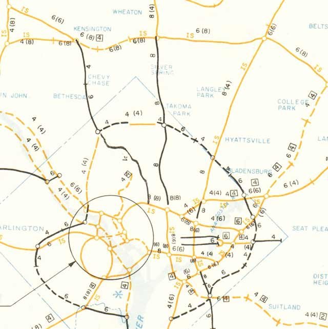
To better understand the planning dynamics, with what occurs within the U.S. and elsewhere, examine what occurred within the capital city, Washington, D.C. in the wake of the Kennedy assassination.  To wit, the stymieing of the inside the Capital Beltway segments of I-95, as well as the spur to I-270, following 1962-63, of the B&O Metropolitan Branch RR/above ground WMATA Red line/MARC/CSX corridor, agreed upon and endorsed by the November 1962 White House transportation report.


  "Significance of Using B&O Route. Use of the Baltimore & Ohio Railroad corridor to bring Routes 70-S and 95 into the city is the key to meeting the need for additional highway capacity in northern Washington, Montgomery County and northwestern Prince Georges Counties and at the same time avoiding the substantial relocation of persons, loss of taxable property and disruption of neighborhoods that would result from construction of the Northeast, North Central and Northwest Freeway proposed in the 1959 plan. Further savings are realized by placing the rapid transit line to Silver Spring and Queen’s Chapel in the same railroad corridor."


So why was a promised for summer 1963 further detailed report not released?  


And, why would the report that would be released, October 1964, 11 months after 11-22-63, and mere days before the 1964 U.S.Presidential election, so deviate from the Kennedy Administration plan?


 “ During the preliminary line studies it became evident that in pin pointing the general corridor of the Baltimore and Ohio Railroad in the District of Columbia should only be accomplished only after more detailed investigation of a band of alignments in that area”,


Why would it instead, scrap the tightly aligned B&O Route North Central Freeway.  Instead it examined 37 routes all over the map, with a recommended route primarily along the B&O.  But that variant had outright ridiculous deviations.  In the D.C. neighborhood of Brookland, it was pushed needlessly through the Turkey Thicket neighborhood so as to move it a bit further away from Catholic University of America).  And even worse, in Takoma Park, Maryland, deviating about 1/3 mile from the B&O insanely slashing through charming late 1800s neighborhoods, for a longer more out of the way route!


Rightfully so, the public broadly opposed such nonsense.  But strangely, indeed weirdly, the press failed to ask why the plans were so botched from what was proposed under the Kennedy Administration, with zero public mention by the Johnson Administration asking why.


By November 1966, a "supplementary" North Central Freeway report was released, that was on the right path, with a tightly aligned B&O route.  It could have used further refinement, such as making the portion just inside the District into a full cut and cover tunnel, rather then simply a widening of the existing elevated corridor at Takoma Station. Public opposition was nonetheless considerably less than the evil 1964 plan.  However, instead of further design refinements, the feds went backwards.  See 1967 Duncan Wall letter to Spiro Agnew.  By mid 1967, officials from the then recently crafted Federal Highway Authority publicly announced they were still favoring  that evil 1964 plan.  Public opposition was again heightened, and the previous approvals of the U.S. National Capital Planning Commission.were reversed by late 1968, and formally "de-mapped" by the early to mid 1970s. And quite tellingly, the federal documents concerning these "de-mappings" show, NOT the alignments of 1962 or 196, but instead that from 1964!


This was clearly and blatantly a crafted scuttling, assisted by a complacent and undeniable centrally controlled press, in the wake of the J.F.K assassination, for the sake of keeping the I-95 North Central Freeway from being constructed along the sole agreeable route - the B&O - with its single most important real estate holding being Catholic University of America, owned of course by the Catholic Church.


The propaganda behind this had two main thrusts: completely ignore this post 11-22-63 planning perversion; and pretend to this very day, that the U.S. was somehow too poor to afford constructing such urban expressways (which in this case would obviously MUST be enclosed within tunnel box with exhaust filtration, and best covered with new linear parkland), with the insistence that such facilities MUST be cancelled "for all time".


They would mean that literally. 


No discussion of long term planning, to say build an expanded railroad with the WMATA line and at least a extra set of tracks to separate MARC and CSX freight, nor a segmented expressway construction of initial box tunnels with space for a supplementary set to be opened when auto emission standards had resulted in a population of cleaner automobiles.


And therefore, NO program at a minimum to leave space for any such corridor improvements.


By the early 1980s, the authorities permitted development encroachment.  Just north of the Turkey Thicket neighborhood, the westernmost properties of Catholic Sisters College, previously suggested as a new industrial area for relocating businesses from directly alongside the B&O, was filled with new houses.(despite the District's shortage of industrial spaces).  And horrifically, the lightly developed, virtually building free industrial strips on BOTH sides of B&O just outside the District in downtown Silver Spring went under assault by developers insistent upon erecting large office towers, under the notion that people using the passenger rail must not have to walk perhaps a quarter or half a block to work.  No, they had to jam such buildings directly abutting the railroad with no more than 20 or so feet, the first being the office tower placed along the T.W. Perry property just north of the Silver Spring Metro, DIRECTLY on the B&O Route North central Freeway's long agreed path.  And if anyone had the idea of placing it to the B&O's west side, that area was subsequently filled with office towers, opened by 1993 and used by the National Oceanic Administration.


With the corridor in Silver Spring so blocked (and therefore requiring substantial removal by the righteous use of eminent domain for public use at perhaps well over $100 million), the corridor remained clear to the south well into the 1990s.  The Takoma Station area remained essentially flanked by parking lots, as did the stations further south at Fort Totten, and in Brookland, with a clearing next to the Pizza Hut just south of Catholic University of America.  That is, until following the publication of an article by yours truly in the July 1997 Takoma Voice, featuring the idea of a revived B&O N.C.F, as an underground, encased, set of cut and cover tunnels, including such for actually removing the elevated railroad, with the WMATA Red line and the MARC/CSX tracks relocated underground.  Include a replica of the historic 1880s Takoma station building within the new park space atop, which would be a part of a new grand northern D.C. linear park/what could be called the North Mall, in what would be called the Grand Arc project.


So what happens?  


Did the feds even bother considering the idea? 


Seemingly not.


But get this, suddenly there is this heighten effort to constrict the corridor with new "transit oriented" development.


A Yale University School of Architecture graduate starts a project to place a new residential building "Elevation 314" about 15 feet or so from the railroad's eastern side, in a blissful disregard of blatantly violating safety, next to heavy freight trains, a derailment of which would send freight cars directly into people's apartments/condos!  As if on cue, projects spout up on the corridor's west side, likewise within a freight rail derailment zone, and at a lower elevation with like safety concerns, for new residential buildings using wood frame construction touted as cheaper!


Further south, particularly in Brookland, new real estate development springs up like mushrooms, on both sides of the corridor.


And likewise further south.  Both around the mouth of the downtown interceptor, the underground Center Leg/better known as the 3rd Street Tunnel, and with that facility itself with the 2014+ "air rights" project which steal more than half the facility's built capacity, (not even leaving sufficient shoulders!).  Yours truly writes a series of articles at my D.C Expressway planning blog "A Trip Within The Beltway".  But not anyone else!  The media, press, television and internet ALL completely ignore the right of way surrender!  Yes, you read that right.  The media is so obviously controlled, that they abjectly fail to even dare mention this dirty deal, upon this "air rights" project, upon that downtown open trench expressway alongside Georgetown Law Center (the law school of Jesuit run, (Catholic Church owned) Georgetown University.


Just connect the dots.  The expressways are scuttled by obviously perversion of planning and manipulation of popular opinion by an orchestrated mass media, further propagated by likewise controlled activist organizations spouting the doctrinaire anti urban expressway agenda of the counter reformation.


Saturday, December 25, 2010

A Christmas Wish List: Most Needed Road Projects

A mix of needed road projects,

San Francisco:
Strictly Highway
- 19th Street Corridor Tunnel
- Central Freeway Alternative Tunnel
- 280 Embaracdero Tunnel

New York Greater Metropolitan Area:

Strictly Trains- #7 extension to Secuscus
- PA station additional tube
- Upgrade NE Corridor for higher speed to further rail as alternative to flying

MultiModel- Cross Sound Tunnel- I-287 extended to Long Island Rt 135 with extra capacity for RR
- Cross Harbor (New Jersey to Brooklyn RR and vehicular highway tunnel with tunnel extension via Brooklyn to Conduit Boulevard-JFK Airport), with Interboro (Brooklyn-Queens) Tunnel- via concrete box enclosures sunk and buried primarily via existing RR right of way. (Facebook page)
- Replacement Tappen Zee Bridge with twin duel level spans with MetroNorth

Strictly Highway- Cross County 'Parkway' Western Extension to New Jersey as mixed use to I-87
- Cross County Eastern Extension Tunnel to I-95/New Roch City
- Cross County Arterial (former NYW&'Boston' RR through New Rochelle, Pelham and Mount Vernon)
- 178th and 179th Street Recommissioned Local Relief Tunnels, with Alexander Hamilton Bridge Reconstruction Project
- I-87 Deegan Reconstruction to 4 lanes minimum per direction with full 12 foot width lanes and shoulders with waterfront Cromwell Avenue Tunnel, and full cut and cover incorporationing the adjacent right of way now partially encroached upon in the northren Bronx.
- Mid-Town Manhattan Expressway Tunnel, once proposed as alternative to above ground Mid Town Manhattan Expressway
- Mid-Town Tunnel 3rd tube
- Lincoln Tunnel 4th tube, NJ 495 approach reconstruction 4 lanes min. per dir with greater cover and shoulders
- Holland Tunnel Augmentation with Canal and Broome-Delancy Street Bypass Tunnels
- Westway/Westway variant

Baltimore:
Multi-Model:Howard Street Tunnel Alternative, with I-83/MLK 295 Connection
Suggested additions?


Washington, D.C.:
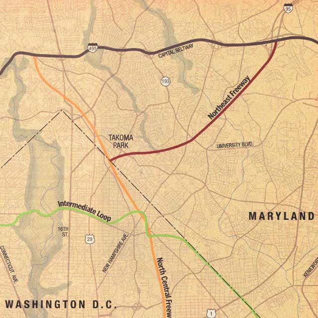
I-95 PEPCO-New Hampshire Avenue-Metropiltan Branch Grand Arc promenade covered multimodel highway-RR tunnel, with K Street-New York Avenue- East Capitol Street Bridge Underground Inner Loop, with reconstruction of SW-SE Freeway underground, with new Washington Channel Tunnel

Saturday, December 26, 2009

Washington Post Continues Lying About D.C. Freeways

The Washington Post continues its efforts to misinform the public about the feasibilities of completing the Washington, D.C. freeway system

From A Trip Within The Beltway:

http://wwwtripwithinthebeltway.blogspot.com/2009/12/washington-post-continues-lying-about.html

From The Washington Post obituary of Peter S. Craig:
http://www.washingtonpost.com/wp-dyn/content/article/2009/12/20/AR2009122002242.html

For more than two decades, Mr. Craig battled business interests, developers and members of Congress who wanted to build a bridge over the Potomac River to carry Interstate 66 into Georgetown and seven multilane highways, which would have destroyed more than 200,000 housing units, many in historically black sections of the city.

This 200,000 dwellings figure is something the Post repeats from its error ridden November 2000 article, which was refuted in the newsnet group misc.transport.road, by participants including Scott M. Kozel, and in a Post forum since made unavailable. It is something that the Post has simply ignored any requests for them to publish a correction, and something they grossly misreported with that November 2000 article's map with the false depiction of the I-95 Northeastern Freeway route.

The Posts' characterization is misleading not only in the number, but in presenting it as static, when in fact the proposed freeways underwent significant routing and design revisions to reduce impacts via the greater use of existing right of ways and of tunnels for pollution containment and land reclaimation. It mentions for instance a North Central Freeway routed via a new swath paralleling the Georgia Avenue corridor, displacing some 4,000 dwellings- in fact the variant of this 1959 proposal appearing within the initial North Central Freeway engineering report in 1964 with the most residential displacement was option #4 "Sherman, 8th Street, Ritchie, Sligo" with figures of 2,770 within D.C., and 440 within Maryland.

But it fails to tell the readers that such a concept was explicitly rejected by the Kennedy Administration, which instead proposed for that highway a tight alignment along the B&O Metropolitan Branch Railroad, which is Washington, D.C.'s sole north-south transport and industrial corridor located roughly mid way between the Potomac River and the eastern north-south portion of the I-494 Capital Beltway.

It fails to mention the 1962 Kennedy initiative, and blurs the history by failing to go into the history of the design evolution of the B&O Route North Central Freeway- for instance not mentioning how the North Central Freeway was effectively sabotaged via the initial engineering report -- dated October 1964 -- disregarding the Kennedy administration idea of the North Central Freeway strictly hugging the B&O railroad together by this report excluding it while presenting an upwards of 37 preliminary and alternative routes[- see plates] mainly nowhere near the railroad, with a recommended route that deviated sharply from the railroad through Takoma Park, Maryland, taking 471 houses in 1 mile where strictly following the railroad would be a fraction of that, that followed the railroad elsewhere just enough to help derail the highway altogether. It fails to mention that it took another two years for the supplementary report to appear that essentially followed the Kennedy idea, yet which was continually sabotaged by officials refusing to commit to it, and such highway "advocacy" as that of the Federal City Council, which only weeks earlier issued a report calling for the North Central Freeway's construction via the earlier 1964 design simply to save some time and money. According to a letter to Maryland Governor Spiro T. Agnew from Takoma Park resident Duncan Wall dated June 1, 1967- excerpt:

The re-studied proposal also tacitly admitted that the route first proposed was needlessly, even carelessly if not ruthlessly, destructive of our communities. The new version hugged both sides of the existing Baltimore and Ohio railway, thus avoiding a new swath of destruction to divide our communities and sharply reducing the number of homes to be taken.


The reduced, re-routed proposal was made public last year with endorsement of D.C. And Maryland highway authorities. The D.C. Portion was forced through the National Capital Planning Commission by votes of representatives of the D.C. Highway Department and of the U.S. Bureau of Public Roads. From this we concluded, reasonably enough, that the highway authorities of the two jurisdiction cons (Maryland and D.C.) had reached a firm understanding with the Bureau of Public Roads.


Many of us were therefore astonished and aroused to preparations for renewed protests when Washington newspapers recently reported that the Bureau has acted to open it all up again. We have not found the Bureau forthcoming with candid information, but the press articles intimate an intention to force Maryland to accept modifications of route or design ostensibly "cheaper."


The result is that the whole controversy, which had been somewhat quiescent, is beginning to agitate the communities again. I can assure you this is so, for although I recently resigned chairmanship of the Metropolitan Citizens Council for Rapid Transit and write this simply as an individual citizen who wishes your administration well, I do remain in close touch with neighborhood sentiment on transportation-related issues.


As Governor of our State, you are in position better than we as private citizens to require straightforward answers from the Bureau of Public Roads.


You can also insure that the Maryland State Roads Commission refuses to go along with divisive proposals which these communities will regard as cause for new protests.


It furthermore fails to discuss the evolution of the I-95 Northeastern Freeway connection from the B&O Route to the I-95 'stumps' at the Beltway via the 195os decision to route it via the more sensitive closer watershed area of Northwest Branch Park in Maryland then that existing 250 foot wide right of way that conveniently parallels I-95 at and beyond the Beltway that would be ignored by official highway planning -- and apparently even the opposition -- until about 1971.

By so blurring the history, it increases the likelihood of confusion between say, 1,095, the figure for completing I-95 from the Maryland line to roughly along the B&O corridor though veering significantly into Brookland along 12th Street as per the 1960 proposal, with that of 1,166 for completing the entire system via the 1971 design, with figures of 148, 600+*, and 172 for the three areas along the downtown Inner Loop segment with displacement, and with a figure of 59 for completing I-95 from the Capital Beltway to just north of New York Avenue via the B&O-PEPCO combination. That figure of 59 includes the cluster of about 24 and about 5 along the northern side of New Hampshire Avenue flanking that large open field of the Masonic Eastern Star Home, just inside D.C., and the 34** at the western edge of Brookland. The I-70S portion of the B&O Route North Central Freeway as per the 1966 supplementary study would have displaced 303 dwellings [372 total NCF - 69 of I-95 segment] within D.C., and 163 *** in Maryland, a reduction from the figures of 720 and 590 for the infamous 1964 "recommended alternative" #11 "Railroad-Sligo East" proposal.

*the 600+ figure is reducible to as few as 34 via my superior alternative employing a some 1,400 radii transition cut and cover tunnel passing beneath the intersection of New Jersey Avenue and N Street, taking advantage of the convenient placement of the Dunbar HS building that seems to me as if it was situated for this very purpose, and transitioning to a multilevel tunnel beneath O Street to its junction with New York Avenue. This alternative entirely bypasses the stand of Victorian development extending from the southwest quadrant of New York Avenue and North Capital Street to New Jersey Avenue, minimally requiring displacement only within the area immediately west to the east side of 4th Street NW between N and M Streets, while sparing those prettier dwellings along M Street nearest to New Jersey Avenue, while providing a greater -- gentler -- tunneled turning transition radi then the 1971 design that had a 50 mph design speed.

**the 34 figure is reducible to about 11 if a portion of the highway is shifted to the railroad's immediate west side which has a generous amount of underutilized industrialized space. (However a development project just approved for this area includes a structure that is directly in the way -- IOW a 'demolition special' -- named the "Arts Walk". Meanwhile, further development along the railroad-industrial corridor promises to place 100s of new 'demolition special' dwellings, with official planning abandoning the idea of at least decking over a short stretch of the railroad.)

***the 163 figure is reducible qualitatively by a redesign that extends the idea of cut and cover tunnels that the 1966 supplementary study report shows alongside Montogomery Community College, further south beneath Takoma Avenue preserving the entire row of Victorian houses that face the railroad that both the 1966 and 1971 plans would have destroyed, along with preserving the sanctity of the landmark Cady Lee Mansion that the 1971 design displaced via replacing the 1966 plans configuration of 3 lanes in each direction flanking the railroad, with that instead placing both directions along the railroad's east side. (The 1966 plan's mainline would miss the houses to the north along Takoma Avenue but the open depressed design would push the replacement Takoma Avenue into the houses). However, the cir. 1966 construction of the Montgomery Gardens apartment complex -- located all the way up to the very edge of the RR's western side created a right of way chock at the expense of the Victorian structures that were built a century earlier with a sensible amount of set back allowing cut and cover highway tunnels.

Hence, if right of ways are preserved, and the designs are so further developed, completing I-95 through Washington, D.C. and all the way to the Capital Beltway in Maryland would displace as few as 74 dwellings- which was about the number that would have been taken for the D.C. Wisconsin Avenue corridor portion of the late 1950s NW Freeway.

Wednesday, December 23, 2009

How JFK's D.C. North Central Freeway Was Sabotaged

to effectively stay away from Catholic University of America,
and keep any such freeway far away from, let alone through the field of the Masonic Eastern Star Home on New Hampshire Avenue


As with anything, just connect the dots with the most influential property owners along a given route...
excerpted from:
http://cos-mobile.blogspot.com/2008/07/homeland-security-goal-would-be-better.html


1959

The cancellation of the NW Freeway led to the 1962 JFK Administration proposal of replacing the 1959 plan for three separate northern radial freeways with a 2 into 1 "Y" Route upon the B&O Metro Branch RR-industrial corridor that runs next to the campus of Catholic University of America. This was to occur with essentially the rail transit network that was built for WMATA.

1962

That plan would be effectively undermined politically via the subsequent 1964 North Central Freeway reports' failure to follow the JFK plan with up to 37 studied routes largely nowhere near this rr and with a recommendation running along the rr in some areas only to deviate significantly directly through old neighborhoods with far far higher local impacts -- 471 free standing dwellings for the 1 mile segment through Takoma Park, Maryland upon a route not only far more destructive but longer and less direct then JFK's B&O "Y" route.

1964

Veers about 1/2 mile away from the B&O railroad on new swath through old neighborhoods in Takoma Park, Maryland, taking 471 houses for the 1.1 mile segment, before rejoining the railroad immediately north of New Hampshire Avenue.

This route was longer and less direct.

Route #11 at New Hampshire Avenue, veering away from the B&O railroad into Takoma Park


1964


1966

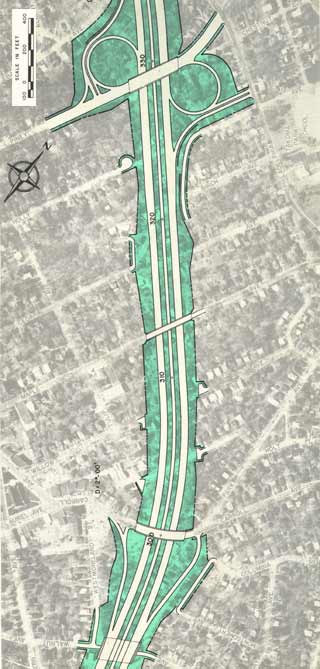
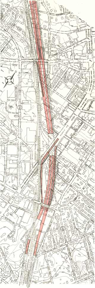
It was not until 1966 that a "supplementary" North Central Freeway study with the JFK B&O route appeared; it eliminated the separate swath in Takoma Park by "hugging" the railroad's flanks at the edge of Takoma Park, with various sort tunnels to swing the highway to one side or the other railroad, such as alongside Montgomery Community College, with a proposal to effectively do the same alongside Catholic University and Brookland via "air rights" development.

1966


1971

The 1971 plan extends the highway cover southward to Rhode Island Avenue, yet inexplicitly deletes the northern segment alongside the main campus of Catholic University of America, continuing its traditional isolation from the east .

All of this was undermined by various politician's suggestions as late as 1968 in favor of the earlier route from 1964 as "less expensive".

So would a change in the route in the vicinity of Fort Totten to use more parkland, creating a new objection in the 1966-71 plan absent from the 1964 plan.

1964 plan which follows the railroad at Fort Totten


1966 plan which veers to the west at Fort Totten


So conceivably did the 1971 plan's to bury the highway segment through Takoma, D.C., but with a catch: whereas the 1966 plan flanked the railroad -- that is a 3/RR/RR/3 configuration -- the 1971 plan placed both directions of the highway along the railroad's eastern side, thus placing it in direct conflict with the landmark Cady-Lee mansion on the corner of Eastern Avenue and Piney Branch, necessitating its removal, whereas the 1966 plan avoided this.

1966 I-70S
Cut and cover tunnels
Silver Spring, Maryland
alongside Blair Park/Montgomery Community College


1966 I-70S North Central Freeway
flanks the railroad
in Takoma, D.C.


1971 I-70S North Central Freeway
all on the eastern side of the railroad

No plan was drawn up via the authorities to tunnelize this segment of highway with highway carriageways flanking the railroad to preserve the Cady Lee mansion as well as the houses to the north facing Takoma Avenue. The Cady Lee mansion, built cir 1884, is the northernmost house within D.C. along the railroad's eastern side.


Why add objections lacking in earlier plans?

Doing so would only continue to undermine this highway's political support, doing so pretty much by the time of the final re-routing with the change of the I-95 Northeast Freeway's route from Northwest Branch Park/Fort Drive, to the PEPCO power line/New Hampshire Avenue route.

D.C. I-95 Northeast Freeway routes
1960-1973

1960 report has I-95 in Maryland via Northwest Branch and entering D.C. passing alongside Catholic Sisters College, which was openly opposed by the Roman Catholic Church and the adjoining residential areas, leading to its abandonment.

The November 1962 White House report retains the Maryland Northwest Branch routing, while, for D.C. adopting the Fort Drive right of way between Galatin and Galloway Streets NE- which is the routing adopted by the subsequent 1964, 1966 and 1971 study-reports.

The 1971 study-report presents that option of the subsequent PEPCO Power Line right of route, in order to preserve parkland by instead re-utilizing the existing 250 foot clear cut power line right of way that extends from outside the I-495 Capital Beltway to some 1,600 or so feet from the Maryland D.C. line alongside New Hampshire Avenue, to then travel about another 1,600 feet to join the B&O railroad corridor.

Below is the most significent property along the connecting segment of B&O-PEPCO I-95.
-------

Masonic Eastern Star Home
on New Hampshire Avenue
between railroad and the Washington, D.C.-Maryland line


http://www.mei-futures-dc.org/campus

the beautiful, historic grounds of the Masonic and Eastern Star Retirement Home at 6000 New Hampshire Avenue, NE, Washington, DC 20011.

The home was built in 1905 and has retained much of the original architecture throughout recent renovations.


This Masonic Order appears to possess an affinity for this side of Washington, D.C.'s New Hampshire Avenue, expressed with the early 1900s creation of the Order's Home on 6000 New Hampshire Avenue NE near the border with Maryland, quickly followed by the 1906 start of construction of what became its downtown headquarters new DuPont Circle, at 1618 New Hampshire Avenue NW:


The Perry Belmont Mansion is one of Washington’s finest examples of Beaux Arts architecture. Designed by French architect Eugene Sanson [started in 1906] and completed in 1909, the house remains today much as it was when originally constructed and still contains many of the Belmonts furniture and objects d’art. Mr. Belmont was the grandson of Commodore Perry who negotiated the 1854 Treaty of Amity, which opened the ports of Japan for commerce. During the sixteen years that Jessie and Perry Belmont, who had served as US Ambassador to Spain, occupied the house, dignitaries from around the world were entertained there. The landmarked house was purchased in 1935 by the Order of the Eastern Star for use as its international headquarters. It serves also as the private residence of the Right Worthy Grand Secretary. The Order’s careful stewardship provides Washington with a remarkable example of its built heritage.

Formerly the Perry Belmont Mansion, it was started in 1906 and completed in 1909, at the then-extravagant cost $1.5 million. Perry and Jessie Belmont built the mansion for the specific purpose of entertaining not only notables of Washington, but also dignitaries from all over the world. The building was only used during the Washington party season (about two months each year) and special events. It was designed by Eugene Sanson, a famous French architect who had designed many grand homes and chateaus in Europe. He was renowned for his use of light and space, and for his beautiful staircases. Long before the acquisition of the building by the General Grand Chapter in 1935, it was a site of elegance, gracious and grand hospitality, of distinguished diplomats, world-renowned guests and romance.

The Belmonts entertained lavishly and had a staff of approximately 34 servants. They used the house from 1909 to 1925. It was then closed and put on the market for sale with the stipulation that it could not be altered for 20 years after purchase. The mansion stood empty and unused until 1935, when the General Grand Chapter purchased it. Mr. Belmont, being a Mason and happy to be selling it to someone who would take care of it, sold it to The General Grand Chapter for $100,000. As part of our agreement with Mr. Belmont, The General Grand Chapter law states the Right Worthy Grand Secretary must live in the Temple. So the building is still a working private residence as well as our headquarters. Many furnishings, including several Tiffany vases, 37 oil paintings, Louis the 14th and 15th furniture, china and oriental rugs were included with the purchase of the Temple and are still on display for our members and their guests to enjoy on tours. Chandeliers throughout are gold gilt and hung with hand-carved rock crystal drops – some with amethyst as well. There are eleven fireplaces, most with hand-carved marble mantles. All the marble in the house was brought from Italy, all the wood from Germany and all the metal fixtures from France.
-------

PEPCO/New Hampshire Avenue
1971- dropped by Maryland July 16, 1973

In my studies of numerous historical information sources regarding this highway planning, I have yet to encounter anything on the Order of the Eastern Star's opinions- for instance did they ever request making the depressed segment through their property as a tunnel to preserve the home's sanctity?

Likewise with that of Catholic University of America- did they for instance object to the proposed highway lid's shortening in the 1971 plan versus the 1966 plan which extended further north alongside the CUA main campus to Taylor Street?

The Washington Post would completely misrepresent this route
in its November, 2000 article "Lost Highways" by Bob and Jane Levey, with this map turning the I-95 Northeast route away from the field of the Order of the Eastern Star Masonic home property alongside New Hampshire Avenue between the RR and the D.C./Maryland line, and instead upon a highly destructive and fictitious route that appears in no planning documents

Tuesday, December 15, 2009

DuPont Circle Tunnel Portals

These photoes show the set of portals for vehicular traffic and streetcars included in Washington, D.C.'s latter 1940s DuPont Circle underpass project.

North Portals

South Portals

The set of portals for the streetcars -- those portals furthest away from the circle -- were sealed during the early 1960s.

There existence points to a time when official transportation planning literally covered vehicular roads and rail transit, only to be followed by a popularized single-mindedness during the 1960s of planning only one to grow, while ignoring the other.

Thursday, August 14, 2008

Washington, D.C. I-395 Gateway Chock

Sole remaining sliver of land alongside New York Avenue for I-395 tunnel extension to get new buildings via development company whose managing principal got his B.S. in Civil Engineering Degree from Notre Dame University.

More on this planning travesty at the full article at "A Trip Within The Beltway":

http://wwwtripwithinthebeltway.blogspot.com/2008/08/washington-gateway-chock_11.html

Robert J. Murphy


Number "17"
Blocks the valuable O Street axis

Also helps keep DC NE divided by rail by complicating the lowering/covering of the divisive surface railroad this complex would be mere feet away from.
Robert J. Murphy
Managing Principal

Bob Murphy, a founding principal of MRP Realty, has been a leader in the Washington real estate community for nearly two decades. Prior to forming MRP, Bob served as area president for Trammell Crow Company’s development and investment activities in the mid-Atlantic region. During his tenure with Trammell Crow Company, his team was the company’s most active and profitable development operation, developing more than twelve million square feet of space.
Bob has served as chairman of the Northern Virginia chapter of NAIOP; and as a member of the D.C. Central Business BID, the Mount Vernon Triangle CID, and the Urban Land Institute District Council. He holds a B.S. in Civil Engineering from the University of Notre Dame and an MBA in Real Estate Finance from the Columbia University School of Business.

http://www.mrprealty.com/executive_team/robert_j._murphy/index.ashx


Apparantly, the University of Notre Dame has a new medievalist civil engineering program that teaches the chocking of valuable transport corridors without regard to the increase on costs-complexities of constructing much needed highway evacuation routes.

Sunday, July 20, 2008

Homeland Security Goal would be better served by reviving Interstate 70 South through northwest Washington

excerpt from comments of Mark Robinowitz for the DEIS of the ICC, a circumferential highway miles outside northern Washington, D.C.

http://www.permatopia.com/icc/icc-deis-2005-comments.pdf

(excerpt- at page 15)

If the ICC is truly intended to boast "Homeland Security", then additional analysis (in a SDEIS) is needed to determine the feasibility and need for reviving the 1950s era proposal for extending Interstate 70 South (the original name or I-270) inside the Beltway to downtown DC. This proposed road would run through Northwest Washington, near the new headquarters of the Department of Homeland Security (at the former Naval Security Station, next to American University).

1959 Friendship Heights

That was the radial highway that would have passed through Washington's wealthiest, whitest area, taking fewer homes than either the corresponding NCF or NE Freeway as shown in the 1959 Mass Transportation Plan, about 74 from the Maryland line at Friendship Heights to the north head of Glover Archibold Park to continue there south as a parkway, with the 1959 plan featuring a split to an I-70 continuation that would have displaced a few dwellings at the northern edge of the Cleveland Park neighborhood before crossing Rock Cree Park to a continuation through the Mt Pleasant neighborhood that would have displaced far more dwellings to an interchange with the I-66 North Leg of the Inner Loop.

1959 Cleveland Park
(dashed lines indicate tunnel segments)

1959 Mt. Pleasant
(no tunnel segments in less affluent areas)


1959

The cancellation of the NW Freeway led to the 1962 JFK Administration proposal of replacing the 1959 plan for three separate northern radial freeways with a 2 into 1 "Y" Route upon the B&O Metro Branch RR-industrial corridor that runs next to the campus of Catholic University of America. This was to occur with essentially the rail transit network that was built for WMATA.

1962

That plan would be effectively undermined politically via the subsequent 1964 North Central Freeway reports' failure to follow the JFK plan with up to 37 studied routes largely nowhere near this rr and with a recommendation running along the rr in some areas only to deviate significantly directly through old neighborhoods with far far higher local impacts -- 471 free standing dwellings for the 1 mile segment through Takoma Park, Maryland upon a route not only far more destructive but longer and less direct then JFK's B&O "Y" route.

1964

Veers about 1/2 mile away from the B&O railroad on new swath through old neighborhoods in Takoma Park, Maryland, taking 471 houses for the 1.1 mile segment, before rejoining the railroad immediately north of New Hampshire Avenue.

This route was longer and less direct.

Route #11 at New Hampshire Avenue, veering away from the B&O railroad into Takoma Park


1964


1966

It was not until 1966 that a "supplementary" North Central Freeway study with the JFK B&O route appeared; it eliminated the separate swath in Takoma Park by "hugging" the railroad's flanks at the edge of Takoma Park, with various sort tunnels to swing the highway to one side or the other railroad, such as alongside Montgomery Community College, with a proposal to effectively do the same alongside Catholic University and Brookland via "air rights" development.

1966


1971

The 1971 plan extends the highway cover southward to Rhode Island Avenue, yet inexplicitly deletes the northern segment alongside the main campus of Catholic University of America, continuing its traditional isolation from the east .

All of this was undermined by various politician's suggestions as late as 1968 in favor of the earlier route from 1964 as "less expensive".

So would a change in the route in the vicinity of Fort Totten to use more parkland, creating a new objection in the 1966-71 plan absent from the 1964 plan.

1964 plan which follows the railroad at Fort Totten


1966 plan which veers to the west at Fort Totten


So conceivably did the 1971 plan's to bury the highway segment through Takoma, D.C., but with a catch: whereas the 1966 plan flanked the railroad -- that is a 3/RR/RR/3 configuration -- the 1971 plan placed both directions of the highway along the railroad's eastern side, thus placing it in direct conflict with the landmark Cady-Lee mansion on the corner of Eastern Avenue and Piney Branch, necessitating its removal, whereas the 1966 plan avoided this.

1966 I-70S
Cut and cover tunnels
Silver Spring, Maryland
alongside Blair Park/Montgomery Community College


1966 I-70S North Central Freeway
flanks the railroad
in Takoma, D.C.


1971 I-70S North Central Freeway
all on the eastern side of the railroad

No plan was drawn up via the authorities to tunnelize this segment of highway with highway carriageways flanking the railroad to preserve the Cady Lee mansion as well as the houses to the north facing Takoma Avenue. The Cady Lee mansion, built cir 1884, is the northernmost house within D.C. along the railroad's eastern side.


Why add objections lacking in earlier plans?

Doing so would only continue to undermine this highway's political support, doing so pretty much by the time of the final re-routing with the change of the I-95 Northeast Freeway's route from Northwest Branch Park/Fort Drive, to the PEPCO power line/New Hampshire Avenue route.

D.C. I-95 Northeast Freeway routes
1960-1973

1960 report has I-95 in Maryland via Northwest Branch and entering D.C. passing alongside Catholic Sisters College; that route is openly opposed by the Roman Catholic Church and the adjoining residential areas, leading to its re-routing within D.C. via the Fort Drive right of ay between Galatin and Galloway Streets NE. The subsequent PEPCO Power Line right of route was developed in the 1971 report, replacing the Northwest Branch-Fort Drive route in order to preserve parkland and re-utilize n existing 250 foot clear cut power line right of way extending from outside the I-495 Capital Beltway to some 1,600 or so feet from the Maryland D.C. line alongside New Hampshire Avenue, to then travel about another 1,600 feet to join the B&O railroad corridor.

PEPCO/New Hampshire Avenue
1971- dropped by Maryland July 16, 1973

In my studies of numerous historical information sources regarding this highway planning, I have yet to encounter anything on the Order of the Eastern Star's opinions- for instance did they ever request making the depressed segment through their property as a tunnel to preserve the home's sanctity?

Likewise with that of Catholic University of America- did they for instance object to the proposed highway lid's shortening in the 1971 plan versus the 1966 plan which extended further north alongside the CUA main campus to Taylor Street?

The Washington Post would completely misrepresent this route
in its November, 2000 article "Lost Highways" by Bob and Jane Levey, with this map turning the I-95 Northeast route away from its New Hampshire Avenue routing through the field of the Order of the Eastern Star Masonic home, and upon a highly destructive and fictitious route that appears in no planning documents

No northern D.C. radial highway appears in official planning documents after 1973.

A Future Washington, D.C. Big Dig


North Central Freeway- A Trip Within The Beltway
Northeast Freeway- A Trip Within The Beltway
Northwest Freeway- A Trip Within The Beltway
Evacuation Routes- A Trip Within The Beltway

The Washington Post Lies About D.C. I-95