Friday, November 3, 2023

Buffalo, N.Y. Expressway Tunnel/Humboldt Parkway Subjected to Disinformation & Distraction Campaign

See my 2010 article on this project:


https://cos-mobile.blogspot.com/2010/09/cap-buffalo-nys-kensington-expressway.html


The current N.Y.S. Kensington Expressway Tunnel project represents the only sensible alternative configuration, of converting the existing trench expressway into a complete corridor tunnel, with a small extension northward (due to the high excavation requirements of removing rock).  


And it should at the very least be practical as an initial stage for restoring Humboldt Parkway to Delaware Park, with some revisions: perhaps lower it another 10-18 inches for more substantial tree root area, and most certainly extend the project's excavation northward by at least 350 feet, to facilitate a subsequent project to extend the expressway tunnel & restored Humboldt Parkway to Delavan Avenue, and continue the Humboldt Parkway restoration to Delaware Park/Agassiz Circle atop a likewise buried 198 tunnel.


Nonetheless, it has come under attack of large numbers of comments favoring the absurd idea of filling in the existing Kensington Expressway open trench.  That is, to instead place the vehicular traffic upon the surface, necessitating wider roadways and a drastically narrowed green-way median, let alone the significantly steeper ascent grade, for northbound traffic by the Science Museum.


Those that chant "fill it in" claim they seek to restore Humboldt Parkway.  But with 70-80K vehicles daily, they conveniently ignore that the project remains connected to expressways at both ends, and that the original Humboldt Parkway lacked connecting expressways.  They say they want clean air.  Yet somehow repurposing a 65 mph expressway segment as a 30 mph boulevard, with a considerably loader, more polluting northbound climb past the Science Museum owing to a ridiculous edict to destroy urban expressways.
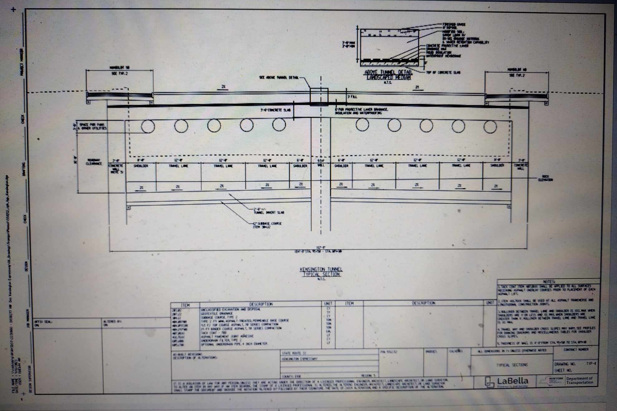


A perusal of the NYSDOT comments received, and of newspaper articles indicates many have so accepted dogma over rationality in favoring a step backwards by filling in the trench for creating an 8 to 10 lane (or perhaps a 6 lane) surface arterial with a considerably narrower attempted recreation of Humboldt Parkway.


Comparably little attention has been given to the planning feasibility.  


Obviously, we don't [yet] have a project extending the tunnel under a linear park to Agassiz Circle because of the costs- am guessing perhaps $4 1/2 billion rather than $0.9 billion, owing to the sheer amount of required excavation.  Alas the 198 connection only has a brief trench passing under only two street crossings, with the rest surface level.


But what about the feasibility of the current project being followed by a second project to extend the Kensington Expressway Tunnel & Humboldt Parkway further north?


For the expressway tunnel to continue north, it must cross a buried 24 ft wide, 14 ft deep concrete waterway conduit for Scajaquado Creek, extending about 19 feet underground.  If this conduit is unaltered, the expressway tunnel would therefore descend from about 25ish to 40 below ground level to pass beneath, increasing excavation amounts.


This 25 to 40 descent would be eliminated if the conduit were replaced and replaced with a new conduit that drops down to pass beneath the underground expressway, and feeds into perhaps an 1/4 to 1/3 mile  of new receiving downstream connector to maintain a gravity flow waterway.


This 25 to 40 descent would alternately be significantly reduced if the conduit replacement  instead remained over the expressway tunnel, with replacing the 24ft x 14ft conduit perhaps with a pair of 48ft x 4ft conduits, or perhaps an array of pipes- shaving about 10 feet from the conduit's depth, therefore allowing the expressway at 30 - 32 feet below ground level, without any lengthy replacement downstream connector.


If the expressway tunnel were only as low as 30 feet underground, that would be more than sufficient than the 27 or 28 feet that activists seek for establishing a more ample space for the roots of the trees


But where is any official or otherwise plan for this required underground waterway/expressway crossing?   The official draft design report (see pp 24-25) can only say:


Extending the transportation corridor to the north beyond Sidney Street was investigated. Scajaquada Creek, carried in a 24.5-foot-wide by 14-foot-high concrete arch culvert located five feet below the expressway, crosses NYS Route 33 approximately 650 feet north of Sidney Street. Extending a potential tunnel north of Sidney Street would result in a major conflict with this sizable, buried structure, which extends both upstream and downstream of the expressway. Engineering solutions to resolve this conflict are complex and would result in substantial impact and cost. A second constraint with extending the Project to the north is the NYS Route 33/NYS Route 198 interchange. This complex interchange has roadways and high-volume ramps crossing one another at three different vertical levels (NYS Route 33 mainline, the ramp from NYS Route 198 eastbound to NYS Route 33 eastbound, and the ramp from NYS Route 33 eastbound to NYS Route 198 westbound). Accounting for the differences in ramp elevations while accommodating a tunnel system would require reconfiguring the interchange and would likely require property acquisition


The buried Scajaquado Creek is beneath the overhead pedestrian bridge.


p 47 of 190 https://kensingtonexpressway.dot.ny.gov/Content/files/DraftDesignReport/Appendix%20A1%20Draft%20Design%20Plans.pdf


Extending the tunnel in a separate project requires re-excavating the transition.  Hence to better facilitate this, the current project must be revised to extend the expressway tunnel excavation about another 650 feet to meet the conduit.  This gets the "hard" more time consuming excavation done, so the successive project could instead simply remove comparably soft fill material used for the interim tunnel to surface transition.  This also provides a potential staging area for the successive project to more cost effectively extend the tunnel by small tunnel boring machines (TBM) used in underground utilities, perhaps 5 or 6 feet as the initial stage of excavating the extension towards Delavan Avenue. 


This project is to be an initial stage project.


For it to be so, it must facilitate rather than hinder the multi stage process.


Yet as it now is, it falls markedly short with its limiting its excavation to simply the new tunnel to surface transition between Sidney Avenue and Hamlin Road.  This means that the successive future project to extend this tunnel must perform the entire excavation between Sidney Street and Delavan Avenue excavation, including having to dig out the initial project's tunnel to surface transition, where traffic must be maintained throughout the construction project.


Considerably more suitable is to extend the project to include the anticipatory subsequent tunnel extension's initial 650 feet of hard excavation to meet the buried Scajaquado Creek conduit, and have the interim ascent/descent transition supported by fill that would be considerably easier to remove.


Cosmobile Cosmopolitan Transport suggested area of extending the Kensington Expressway Tunnel hard excavation up to 650 feet to the buried Scajaquado Creek concrete box conduit, with use of fill supported interim ascent-descent transition, to ease subsequent project to extend the tunnel north with an underground staging area of small TBMs for the successive project's excavation..


Thursday, October 26, 2023

How Battery Park City Authority Increased Costs of West Side Highway Tunnel


Textbook 101 case study of the elites' disrespect for civil infrastructure planning and design.


People opposed Robert Moses idea of modernizing the elevated West Side Highway.


People demanded a tunnel expressway replacement, within new rectangular box tunnels buried along the shoreline.  The World Trade Center project created an enormous amount of excavated material.  Hence its logical use for the initial phase of a planned landfill extension of western shoreline of Manhattan Island, south of 29th Street.  The tunnel would thus use the innermost strip of this new landfill.


Here are the initial planning, from the 1966 Lower Manhattan Study, showing this new rectangular box tunnel within the innermost portion of its new WTC-BPC landfill, before turning inland to parallel the existing bulkhead.


Note the improved geometry for the West Side Highway link with the Brooklyn Battery Tunnel.


Note the space of the new landfill used for the new expressway tunnel, that bypasses West Street, avoiding a need to excavate while maintaining Brooklyn Battery Tunnel approach traffic.


Battery Park City Authority, established 1968 dictates ban on using any part if its landfill for expressway tunnel, mandating its relocation to within West Street- thus requiring an excavation with potential underground utility matters, while denying the improved geometry for the ramps into the Brooklyn Battery Tunnel.


Such an excavation, together with the issues of underground utilities, made the southernmost portion of the future underground WSH more expensive to construct.  How much?  $300 million?  $600 million? $850 million?  Strange how we saw so little attention to this.


Where was any protest movement against the plans for the World Financial Center, and the other B.P.C. buildings facing inland?  Any demands to modify the plans to shift the eastern facing building line west to preserve the underground easement for a future West Side Highway Tunnel


 The 1974-1985 Westway project would be routinely bashed by supposed "fiscal conservatives" out to block wasteful government spending.


So, at anytime from 1968 onwards, where were the great protests about the BPCA blocking the use of its innermost landfill, by the multitude of "fiscal conservatives" that we subsequently saw bash the Westway project?


Sunday, October 22, 2023

Hartford 400 Plan


New revised plan for restructuring-reconstructing the Hartford, Connecticut  expressway system, with cut and cover tunnels for existing and for new expressway segments, the deletion of the huge array of expressway links with the establishment of a new east to west urban boulevard. 


 https://hartford400.org/


 Existing and proposed


Wednesday, October 18, 2023

N.Y. Requires Brooklyn-Queens Expressway Reconstruction


To this very day, N.Y.'s "leaders" wallow in circles over what to do about the B.Q.E.?


The B.Q.E. was originally built during the 1940s.  Its recent project to replace its Kosciusko Bridge upped capacity from 6 to almost 10 lanes.  Yet nothing has yet been done to reconstruct anything to the south.  Nothing about the overloaded segment from the Long Island Expressway to the Williamsburg Bridge.  And only discussion about its two other segments to the south, namely the portion with the other bridge into Manhattan connections (that includes the architecturally magnificent triple deck cantilever.), and its southernmost segment known as the Gowanus Expressway.


In 1997, the once highly respectable Regional Plan Association spotlights the idea of a Gowanus Expressway Tunnel, to replace its  viaduct - with tunnel- seen as cut and cover flanking the existing expressway viaduct,, so featured at a panel at their April 1997 one day conference.


Simultaneously, an architect announce the idea of what is now called the Cross Downtown Brooklyn Tunnel: a straight line tunnel to depart and reconnect with the BQE.  This would create a perpetual benefit of a significant time savings for through traffic not destined to the bridges to Manhattan.  And it would siphon such traffic to allow re-striping from 3 to 2 through lanes per direction through the cantilever.


NYSDOT subsequently issued a study of  the Gowanus Expressway Tunnel, presenting a variety of route options, though without the straight line tunnel.

https://www.dot.ny.gov/regional-offices/region11/projects/project-repository/gowanus/index.html

https://www.dot.ny.gov/regional-offices/region11/projects/project-repository/gowanus/tun_alt.html


THB
Harbor / Bulkhead


TB
Bulkhead


T1
First Avenue 


T2
Second Avenue 


 T12
First and Second Avenues 


The Gowanus Expressway study has been supplemented with a study about its connecting BQE segment north.  


The Cross Downtown Brooklyn (CDB) Tunnel would supplement the existing B.Q.E., which is retained as a collector distributor system, and re-striped from 3 to 2 lanes per direction. 


It is the sole tunnel option that adheres to the concept of the shortest link being a straight line.  Nonetheless, this subsequent study report includes it with other alternative tunnel routes, all of which are considerably lengthier (more expensive) while not providing the time savings advantage.


 The tunnel route alternatives so studied are:


1. T-1 running under downtown Brooklyn by Henry Street
2. W-1, a variation of T-1 also running under downtown Brooklyn but further west by Hicks Street
3. T-2 following the existing BQE corridor alignment
4. T-3 outboard tunnel following an alignment similar to the existing BQE but further west and into the river.
5. W-2 straight line tunnel between Exit 24 of the BQE (by Prospect Expressway) and Exit 30 of the BQE to the East of Washington Avenue
6. W-3 outboard tunnel between Sunset Park and Exit 33 (only qualitative study based on length)
7. W-4, a variation of W-2 between Exits 24 and 30 that extends further south than Prospect Street where it joins a Gowanus tunnel alternative that follows the bulkhead.


W2 straight line tunnel to the northern end of the existing Gowanus Viaduct, and W4, a variant of W2 extending further south to a Gowanus Tunnel along the bulkhead.


W2 and W4 are to be moled tunnels via TBMs, as they must to the north to pass fully beneath the street grid.


The study enumerates several variants of TBM highway tunnels, with either 2 or 3 travel lanes per roadways with 2 foot left and 4 foot right shoulders:


1) Single 66 foot diameter, stacked 3 lane roadways

2) Duel 55 foot diameter, single 3 lane roadways

3) Duel 42 foot diameter single 2 lane roadways

4) Single 54 foot diameter, stacked 2 lane roadways


These TBM tunnels are shown with 2 foot left and 4 foot right shoulders.  This is akin to the recently constructed Seattle Route 99 Highway Tunnel.


As a heavily used interstate highway, and as all new construction, should this several mile long I-278 Cross Downtown Brooklyn Tunnel be so narrow with its lack of sufficient shoulder space?  Imagine the traffic and situations of stalled vehicles in need of service or a tow, and consider the servicemen.  Would we want that with a meagerly 4 foot right shoulder?  Or 6 or 8 feet?


At a minimum, lets provide full 12 foot wide right shoulders.


The authorities prefer a single tunnel bore with stacked, 2 level roadways, as more economic.  With the available 57 foot diameter TBMs as used in Seattle Route 99, this gives too little in safe shoulder space, and hence a somewhat larger bore less, but less than 66 feet..


With the matter of potential EV battery-pack fires, particularly larger vehicles as trucks, we should go with the costlier option of TWO tunnel bores, to avoid stacking one direction atop another.  With the already available 57 foot diameter TBMs, duel tunnel bores would each have a sufficiently wide roadway of a pair of travel lanes with a 12 foot right, and 6 foot left shoulders.


So far, instead of any outcry to provide adequate shoulders, we get the typical post 1963 cacaphony of budget conservatives insisting upon deflecting for the early 1980s elimination of the NYSE stock transfer tax (from a modest 0.1% to effectively 0% with NY Governor Hugh Carey's 1978 legislation to institute a "rebate" (refund) of that tax revenue.  That highways are evil.  That we must view them with disdain and hostility, and hence, that we must remain ignominiously on the matters pertaining to their DESIGN.


We are told to de-map the urban expressways. and change them into surface streets, screw everyone.  Eliminate a grade separated road outright, and fail to even consider the variables of where the traffic would instead, including even the measurable impacts of heavy streams of vehicular traffic.  Sure an urban expressway is going to centralize vehicular emissions due to the volumes.  But is it better to leave everything as is, or to somehow convert an expressway to a boulevard with traffic lights, or is it to modernize and enclose that traffic stream within a new urban expressway tunnel equipped with pollution filtration technologies?


So far the plan has not yet been set.


Its physical realities are that it must be constructed together to the south with the Gowanus Expressway Tunnel, as well as to the north to cut and cover reconstruction of the BQE trench segment alongside and south of the ramps with the Williamsburg Bridge.


Other factors to be determined include what to do about the BQE trench, as well as its elevated segment.
