Sunday, December 31, 2023

High Finance & Infrastructure Development

Imagine one is a part of some entity involved with finance, such as investment firms, private equity, etc.


Should not such entities be concerned with the horrific lack of regard for some rather serious planning?


And I do not mean the "Regional Plan Association".  Sure it has presented some well needed thoughts, though severely inadequately developed.  Such as its proposals for underground versions of the highly needed east west links, as the Lower Manhattan Expressway, and the Cross Brooklyn Expressway- both indisputably required, yet lacking in a fuller outlook, as well as refinement.  Just look at the way they were planned, to provide vital connections, WITHOUT the REQUIRED new capacity for what they would connect.  Everyone knows both the VZN Bridge and the Holland Tunnel & Williamsburg Bridge are at capacity if not over.   Yet neither the CBE nor the LME would have simply connected to these crossings, with at best, a single added two lane outbound tube alongside the Holland Tunnel.  And worse, the LME was to accept traffic from both the BQE/LIE, as well as a Bushwick Expressway, carried upon the antiquated Williamsburg Bridge, plus an expressway spur connecting to the Manhattan Bridge!  Talk about a westbound traffic trap!!!!  And of course these underground roads lacked full encasement, with open air ventilation and echoing noise.  QUITE BAD!   Disagree with the outright "de-mapping" as that would fail to protect the corridors from stupidly placed development while refusing to purchase needed space over the long term (granting residents time to continue their lives before having to vacate).  But it was indeed a wise thing to have not gone ahead with these vital highways as then being planned.  Especially when one considers such RPA foolishness of showing renderings of new decks/tunnel caps in Williamsburg atop the BQE WITHOUT shoulders.  NOT GOOD!

So, where are any efforts, publicly accessible for developing a better designed expressway network for the NYC Metro Region?

The Regional Plan Association made the news way back in 1997 with a panel at their weirdly too short annual conference in Manhattan, held in the morning but not extending far afterwards.  That panel highlighted the efforts of area community activists in promoting the idea of a new expressway TUNNEL along the axis of the Gowanus Expressway.  And simultaneously there was the proposal for a straight line tunnel extension northward - the Cross Downtown Brooklyn Tunnel - to bypass the BQE segment to the west with the cantilever with the connections with the Brooklyn Battery Tunnel, and the bridges.  Accordingly this western segment would be reduced from 3 to 2 lanes in each direction, with the new straight lane tunnel with 2 lanes in each direction.  Yet there appears to be no plan on what happens at the northern end, let alone anywhere else, like the Prospect Expressway.  Obviously we need a broader plan.


So where are any such efforts?


Regional Plan Association could have followed up with subsequent panels at its annual half a single day conference.  Yet in the past 20+ years, nothing (unless I missed something more recently).


And where is high finance?


Well, of course funding anti highway nonsensical propaganda.

https://cos-mobile.blogspot.com/2023/08/the-pseudo-progressive-crusade-to.html


Where are the likes of City Journal?

https://cos-mobile.blogspot.com/2016/02/manhattan-institute-panders-to-princess.html


And how about the local "activism" to essentially preserve an elevated expressway in order to create new waterfront development that is less of an extension of existing neighborhoods, and way more just another new urban enclave like BPC?!


https://cos-mobile.blogspot.com/2009/12/my-conversation-with-shill-for.html


Should not the world of high finance be instead supporting MAJOR EFFORTS to develop and construct a more modern and comprehensive transport network?  Would not Wall Street "investors" be favoring a massive upsurge in infrastructure development encompassing tens upon tens of billions of construction efforts?


Speaking from experience, I myself created the "Takoma Park Highway Design Studio" idea to further such efforts, to present new plans to the general public regarding Washington, D.C.'s atrociously incomplete and inadequate expressway system (which I address in my blog "A Trip Within the Beltway").  I contacted one of that area's supposedly public oriented private planning groups, and was visited by a pair pf their representatives.  The younger of these two appeared interested, but the older one abruptly ended the meeting taking the other guy with him.


https://cos-mobile.blogspot.com/2013/03/ending-defeatism-in-lower-new-york.html


The High Finance CONTEMPT could not be any more obvious:


https://cos-mobile.blogspot.com/2023/10/how-battery-park-city-authority.html


Thursday, December 21, 2023

I-684/NYWB Central Corridor Tunnel at Heathcote, Scarlsdale, and Northern New Rochelle

 I-684 Tunnel, with restored NYWB RR, in the north end of New Rochelle (in my own neighborhood), from the Stratton Road HISTORIC/LANDMARK "Quaker Ridge" Station to the Heathcote Bypass.


Monday, December 18, 2023

N.Y. REQUIRES Constructing Revived Westchester Central Corridor Expressway, as multi model tunnel highway with restored NYWB RR

WESTCHESTER/UPSTATE CENTRAL ARTERY PROJECT


(appended January 20, 2024- since changed, eliminating the California Road and South White Plains "Ridgeway" alignments, and replacing the west of the land-marked station at 556 Stratton Road, with a Hilary Circle routing to allow restoration of the demolished in 2012 Marks Estate Mansion with appropriate complimentary Military School Scale residences with *minimum* 3750 foot square footage, prioritized for existing communities.)


Just consider the ramifications of some emergency requiring evacuating Long Island.


Consider the traffic via the Throggs Neck Bridge.  Yes, long term, twin it & reconstruct and widen the Clearview Expressway primarily as cut and cover tunnel, that extends south/southeasterly (212St/Pl, & Hempstead Avenue), fully encased with exhaust filtration to the vicinity of Belmont Park, and continuing south along the Belt as park covered tunnel.  Ask the locals in the Hempstead Avenue area their assistance in  setting the exact alignment for a pair of 4 lane with full outer shoulder cut and cover tunnels.  Seek their assistance in what to do atop.  Full restoration of existing neighborhood configuration (with the older more architecturally important houses moved/shored up), with or without a new linear park to connect the Belt Park to the Clearview, and with or without some new higher rise residential apartments/condos that would establish a precedent pf providing more generous livable square footage.  Of course we could also include new tunnel caps atop portions of the Belt Parkway, establishing a more capacious park corridor atop that and our new mixed use expressway tunnels southward to the Sunrise Highway (which must get a series of new cut and cover tunnels along the RR corridor to make a full continuous expressway corridor to Amityville (I-78).  And do likewise with the Belt's northern extension, the Cross Island Parkway along the shore to restore local waterfront access.


We all know that the northbound Throggs Neck link would be massively jammed - particularly along the I-95 Cross Bronx Expressway/George Washington Bridge to I-80.  And, in the case of a tsumani, or radiation incident, it does not help that the I-95 New England Thruway runs closely along the Long Island Sound's mainland shore.


So, let's consider an all new link, extending northerly from I-95/Throggs Neck Expressway, past Co Op City and into Westchester County, to carry traffic to and from Long Island to both I-684 AND a new Hastings on the Hudson Bridge to New Jersey's Palisades Parkway.


From the north, this I-684 TUNNEL would extend from a completely reconstructed I-287/I-684 interchange, enter a tunnel alongside Bryant Avenue, before turning south into the NY, Westchester & 'Boston RR corridor - its Westchester County portion dismantled early 1940s  - but still in use in the Bronx as the Dyre Avenue IRT, and connect with I-95 from the south.


This I-684 TUNNEL PROJECT would be designed to include full eventual restoration of the 1912-1937 N.Y., Westchester & Boston RR.


It would start with the initial, southernmost portion, from the IRT Dyre Avenue line, to a connection with the Metro North New Haven line, with expressway completely submerged/enclosed for effective sound containment and exhaust filtration, and with RR initially as a high viaduct (bridge), before descending into a trench/tunnel.


Design would include a new set of reconstructed architecturally faithful mixed use "stations' at Sanford Street, and East 3rd Street, to a connection with the Metro North, with the initial stub of the northern continuation into the North End of New Rochelle.  Have that established as an IRT link (requiring legislation extending that authority) from the Bronx Dyre Avenue line, to MetroNorth New Haven line/AMTRAK.  The continuation north would go to a faithful replication of the Wykagil Station. This RR would enter into a tunnel with the expressway through the northern edge of Ward Acres, and continuing past the historic "Quaker Ridge" Station, continuing to a new station, accessible from the shopping center to the west, behind the historic station building at the Scarsdale 5 Corners Heathecote Junction.  Would continue as tunnel along and past the Heathecote Bypass (which would become a part of this tunnel).  Whereas the I-684 Tunnel would veer from this corridor through the lightly developed area behind Archbishop Stephinac HS & Our Lady of Sorrows Church, this RR would continue north into a new station within the enormous Westchester Mall.  It would then continue north to Westchester County Airport, giving that a DIRECT passenger rail link into downtown White Plains, to Heathecote Junction, Wykagil, and Mt. Vernon.  And we have the option of restoring 4 track service within the Bronx Dyre Avenue line.


This new expressway link starts at the 233rd street northbound lefthand exit.


This project MUST include a suitable reconstruction of I-95 from the I-95/Throggs Neck conjunction.


Ideally it should include reconstructing the 8 lane trench as a 14 lane cut and cover tunnel (so the Throggs Neck link gets a full 8 lane northern continuation).   Yet that could be arguably deferred.  But it is mandatory to extend the outermost northbound lane north past the Pelham Parkway/Shore Road exit.  Move the footbridge 24 feet over, to allow the space for 2 additional northbound lanes, but construct only the first, bringing that to the right-hand exit to the northbound Hutchinson River Parkway.


But would we want to simply add extra traffic to what is rightfully decried as a grotesque waste of space?


Yes, that's right, grotesque.  And I am not just writing about the silly lane drop/traffic choke, further exacerbated by the poor design of I-95 on the inland side of the HRP.  It is an effective wall separating Co Op City from the inland, making it more isolated, less accessible. (How about some proposals for somehow restoring/recreating a portion of the 1960-1964 "Freedomland U.S.A. amusement park).


So why not explore the idea of replacing the I-95 segment from the area of its interchange with the HRP northward alongside Co Op City, to the vicinity of its 233rd Street exit, with a new cut and cover enclosed expressway tunnel, removing the I-95 overpass over Barlow Avenue.  Explore ideas for the surface, new parkland, new recreational facilities, new commercial development, perhaps in the spirit of Freedomland?


We must improve I-95 between the Throggs Neck Expressway (easily widened to 4 lanes in each direction) and 222nd Street (spot of the northbound lefthand exit that veers inland onto Baychester Avenue.  BEST OPTION: a UNIFIED PLAN, addressing the entire stretch, including replacing the 8 lane trench with a 14 lane set of rectangular box expressway tunnels,equipped with exhaust filtration.  Widen it away from neighborhoods, and replace expand the adjacent parkland atop.


WIDEN the 222nd Street ramps to a minimum of 3 LANES PER DIRECTION.


Connect these ramps into an underground link turning to run along the east side of the conveniently situated Dyre Avenue IRT segment of the 1911-1937/43 New York, Westchester & Boston RR, that had its Westchester County segments foolishly demolished during a horrifically caustic scrap medal drive costing way more in demolished assets.


RECONSTRUCT the NY, Westchester & Boston main corridor to White Plains, and eventually a further continuation northward, exploring different ideas of such use, including Westchester Airport, all doable incrementally.


RECONSTRUCT architecturally faithful replicas of the original Sandford Boulevard, East 3rd Street, and Metro North transfers in Mt. Vernon, and the Wykagyl in New Rochelle, and 5 Corners in Scarsdale.  Have the expressway tunnel veer to the left, away from the historic "Quaker Ridge" Station at Stratton Road, officially recognized landmark, which would be PRESERVED!  Have the area of the removed houses made into an expanded Carpenters Pond area preserve.  Have the expressway tunnel then veer right of Weaver Street, avoiding the commercial properties, before turning back onto the Heathecote Bypass alignment.  Purchase the required houses for removal, and create a linear green park atop the railway/expressway tunnel.  Use electronic tolling to offset expenses and restrict use.


BUT MAKE IT MORE UNDERGROUND.  A revived NY,W&B makes perfect economic sense with contained development density, and future extensions northward.  And it is going to introduce significant rail car traffic, especially if ever adopted by AMTRAK.


Ask Eastchester Heights their preference regarding a NYW&B station, as well as expressway access ramps. 


Have it as a cut and cover expressway tunnel alongside the Dyre Avenue IRT line to the Bronx-Westchester County line, and along and or beneath it, northward into the City of White Plains, turning to follow Bryant Avenue to a reconstructed interchange with I-287 and I-684.  Our I-684 Tunnel!  It can take heavy northbound traffic from the Throggs Neck Bridge from Queens/Long Island, effectively upstate to I-84.  


Let's include a new water spillway to alleviate flooding on the lower Hutchinson River.


It MUST include, or at least be designed to include, a western split from Eastchester Heights.  This would run through Eastchester in a tunnel following California Road and crossing under Route 22 (with access ramps to the retail area).


From there, it could emerge upon a high arched bridge crossing over the Bronx River valley, remaining elevated, to alongside the former Alexanders, crossing over Central Avenue and entering a cut and cover tunnel under Jackson Avenue and emerging again (displacing the nursing home near the Sprain Parkway), and continue to a new interchange with I-87.  This would allow traffic from Long Island the options of transferring to these local arterial.  I would call this segment I-687.


But rather than simply connecting with I-87, have it continue west into Hastings on the Hudson to a new bridge crossing the Hudson River, to connect with the Palisades Parkway New Jersey.  


From I-95 by Co Op City, it would be a 10 lane expressway tunnel (accepting 4 northbound lanes from I-95 and 2 northbound lanes from a subsequently constructed Route 1 separate electronically tolled traffic tunnel to Hunts Point favoring trucks).   Of these, 2 lanes would veer off into the tunnel connections for an I-80 Tunnel along 2nd Street in Mt Vernon heading west.  I-684 expressway tunnel would be 4 lanes northbound, and 5 lanes southbound (for a southbound I-684 Tunnel connection to the I-80 Tunnel), continuing underground into Chester Heights, to an underground split to a pair of this tunnel's extensions, 3 lanes northbound, and 2 lanes southbound- to I-684, and 3 lanes each direction towards the new trans Hudson span to the Palisades Parkway.  This overall "Y" Route arrangement establishes an invaluable vital traffic artery between Queens/Long Island, northward to I-684, and westerly to the Palisades Parkway.  


UNCORK the northbound Throggs Neck traffic, ported northward to I-684 AND the west via a Hastings on the Hudson Bridge to the Palisades Parkway- considerably superior to porting said traffic all through Brooklyn and Staten Island to a NJTK and I-78.


 It is ABSOLUTELY VITAL/REQUIRED/NECESSARY for evacuation from Long Island.


Friday, November 3, 2023

Buffalo, N.Y. Expressway Tunnel/Humboldt Parkway Subjected to Disinformation & Distraction Campaign

See my 2010 article on this project:


https://cos-mobile.blogspot.com/2010/09/cap-buffalo-nys-kensington-expressway.html


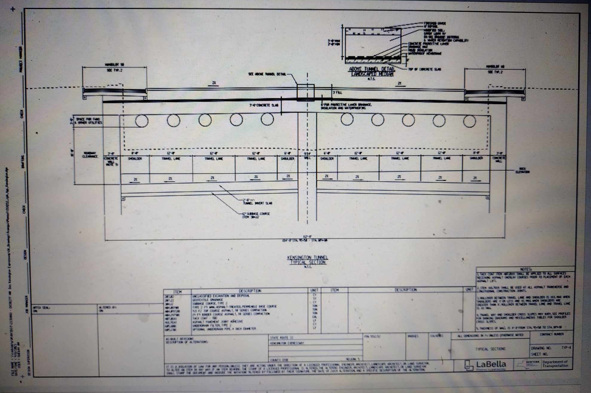
The current N.Y.S. Kensington Expressway Tunnel project represents the only sensible alternative configuration, of converting the existing trench expressway into a complete corridor tunnel, with a small extension northward (due to the high excavation requirements of removing rock).  


And it should at the very least be practical as an initial stage for restoring Humboldt Parkway to Delaware Park, with some revisions: perhaps lower it another 10-18 inches for more substantial tree root area, and most certainly extend the project's excavation northward by at least 350 feet, to facilitate a subsequent project to extend the expressway tunnel & restored Humboldt Parkway to Delavan Avenue, and continue the Humboldt Parkway restoration to Delaware Park/Agassiz Circle atop a likewise buried 198 tunnel.


Nonetheless, it has come under attack of large numbers of comments favoring the absurd idea of filling in the existing Kensington Expressway open trench.  That is, to instead place the vehicular traffic upon the surface, necessitating wider roadways and a drastically narrowed green-way median, let alone the significantly steeper ascent grade, for northbound traffic by the Science Museum.


Those that chant "fill it in" claim they seek to restore Humboldt Parkway.  But with 70-80K vehicles daily, they conveniently ignore that the project remains connected to expressways at both ends, and that the original Humboldt Parkway lacked connecting expressways.  They say they want clean air.  Yet somehow repurposing a 65 mph expressway segment as a 30 mph boulevard, with a considerably loader, more polluting northbound climb past the Science Museum owing to a ridiculous edict to destroy urban expressways.


A perusal of the NYSDOT comments received, and of newspaper articles indicates many have so accepted dogma over rationality in favoring a step backwards by filling in the trench for creating an 8 to 10 lane (or perhaps a 6 lane) surface arterial with a considerably narrower attempted recreation of Humboldt Parkway.


Comparably little attention has been given to the planning feasibility.  


Obviously, we don't [yet] have a project extending the tunnel under a linear park to Agassiz Circle because of the costs- am guessing perhaps $4 1/2 billion rather than $0.9 billion, owing to the sheer amount of required excavation.  Alas the 198 connection only has a brief trench passing under only two street crossings, with the rest surface level.


But what about the feasibility of the current project being followed by a second project to extend the Kensington Expressway Tunnel & Humboldt Parkway further north?


For the expressway tunnel to continue north, it must cross a buried 24 ft wide, 14 ft deep concrete waterway conduit for Scajaquado Creek, extending about 19 feet underground.  If this conduit is unaltered, the expressway tunnel would therefore descend from about 25ish to 40 below ground level to pass beneath, increasing excavation amounts.


This 25 to 40 descent would be eliminated if the conduit were replaced and replaced with a new conduit that drops down to pass beneath the underground expressway, and feeds into perhaps an 1/4 to 1/3 mile  of new receiving downstream connector to maintain a gravity flow waterway.


This 25 to 40 descent would alternately be significantly reduced if the conduit replacement  instead remained over the expressway tunnel, with replacing the 24ft x 14ft conduit perhaps with a pair of 48ft x 4ft conduits, or perhaps an array of pipes- shaving about 10 feet from the conduit's depth, therefore allowing the expressway at 30 - 32 feet below ground level, without any lengthy replacement downstream connector.


If the expressway tunnel were only as low as 30 feet underground, that would be more than sufficient than the 27 or 28 feet that activists seek for establishing a more ample space for the roots of the trees


But where is any official or otherwise plan for this required underground waterway/expressway crossing?   The official draft design report (see pp 24-25) can only say:


Extending the transportation corridor to the north beyond Sidney Street was investigated. Scajaquada Creek, carried in a 24.5-foot-wide by 14-foot-high concrete arch culvert located five feet below the expressway, crosses NYS Route 33 approximately 650 feet north of Sidney Street. Extending a potential tunnel north of Sidney Street would result in a major conflict with this sizable, buried structure, which extends both upstream and downstream of the expressway. Engineering solutions to resolve this conflict are complex and would result in substantial impact and cost. A second constraint with extending the Project to the north is the NYS Route 33/NYS Route 198 interchange. This complex interchange has roadways and high-volume ramps crossing one another at three different vertical levels (NYS Route 33 mainline, the ramp from NYS Route 198 eastbound to NYS Route 33 eastbound, and the ramp from NYS Route 33 eastbound to NYS Route 198 westbound). Accounting for the differences in ramp elevations while accommodating a tunnel system would require reconfiguring the interchange and would likely require property acquisition


The buried Scajaquado Creek is beneath the overhead pedestrian bridge.


p 47 of 190 https://kensingtonexpressway.dot.ny.gov/Content/files/DraftDesignReport/Appendix%20A1%20Draft%20Design%20Plans.pdf


Extending the tunnel in a separate project requires re-excavating the transition.  Hence to better facilitate this, the current project must be revised to extend the expressway tunnel excavation about another 650 feet to meet the conduit.  This gets the "hard" more time consuming excavation done, so the successive project could instead simply remove comparably soft fill material used for the interim tunnel to surface transition.  This also provides a potential staging area for the successive project to more cost effectively extend the tunnel by small tunnel boring machines (TBM) used in underground utilities, perhaps 5 or 6 feet as the initial stage of excavating the extension towards Delavan Avenue. 


This project is to be an initial stage project.


For it to be so, it must facilitate rather than hinder the multi stage process.


Yet as it now is, it falls markedly short with its limiting its excavation to simply the new tunnel to surface transition between Sidney Avenue and Hamlin Road.  This means that the successive future project to extend this tunnel must perform the entire excavation between Sidney Street and Delavan Avenue excavation, including having to dig out the initial project's tunnel to surface transition, where traffic must be maintained throughout the construction project.


Considerably more suitable is to extend the project to include the anticipatory subsequent tunnel extension's initial 650 feet of hard excavation to meet the buried Scajaquado Creek conduit, and have the interim ascent/descent transition supported by fill that would be considerably easier to remove.


Cosmobile Cosmopolitan Transport suggested area of extending the Kensington Expressway Tunnel hard excavation up to 650 feet to the buried Scajaquado Creek concrete box conduit, with use of fill supported interim ascent-descent transition, to ease subsequent project to extend the tunnel north with an underground staging area of small TBMs for the successive project's excavation..