Saturday, February 27, 2016

1929+ Mid Town Manhattan Expressway Tunnel

from a map found at this article at Wired:

http://www.wired.com/2013/08/hyperreal-cartography-city-maps/


1929 Proposal 
For A 38th Street Mid Town Manhattan Vehicular Tunnel


No further details yet upon what would have been 2 lanes wide, due to the narrow width of 38th Street, such as if this was for a single level tunnel with one lane per direction, or rather a double level tunnel with 2 lanes per direction.

Note the additional proposed vehicular tunnel at the approximate location of the Verrazano Narrows linking Staten Island and Brooklyn.

About a Regional Plan Association proposal in 1937:

http://www.nycroads.com/roads/mid-manhattan/

WHY NOT A MID-MANHATTAN TUNNEL? As early as 1937, the Regional Plan Association advocated construction of a four-lane, twin-tube tunnel under 36th Street and 37th Street. According to the Moses-headed Joint Study, the chief argument against the Mid-Manhattan Expressway Tunnel was its cost. This would have ranged from $119 million for a no-exit, express link between the Lincoln Tunnel and Queens-Midtown Tunnel, to $145 million for a tunnel link that would have provided entrances and exits at 5th Avenue.

The proposed construction method was described in the Joint Study as follows:

It would be necessary to build two separate tubes under adjacent crosstown streets. A two-lane eastbound tube could pass under 29th Street; a two-lane tube westbound under 30th Street. Ventilation buildings would be located in the block between 29th and 30th Streets fronting on the west side of 8th Avenue and the east side of Lexington Avenue. The least costly type of construction for such a tunnel would be the steel-bent and concrete subway-type, installed by cut-and-cover method.

The tunnel providing only two lanes in each direction would, of course, have only two-thirds the capacity of a six-lane expressway. Provision of more than two lanes in each tube is not feasible due to limitations imposed by building foundations on either side of 29th and 30th Streets and extremely high costs. Limited street access in Midtown could be provided in the vicinity of 5th Avenue at a cost that would depend on the degree to which the interchange was developed.

To accommodate future traffic along the Mid-Manhattan corridor, Moses proposed construction of a $120 million third tube to the Queens-Midtown Tunnel. The third tube, which would allow four lanes of traffic in one direction during rush-hour periods, was to be constructed in conjunction with the expressway.


Monday, February 15, 2016

Re-Think New York City La Guardia Airport Expansion Into The South Bronx Proposal

An intriguing idea to expand La Guardia Airport with expanded runways achieved by new landfill displacing Rikers Island, with a new set of entryways in the Port Morris area of the South Bronx, accompanied by upgrades to the passenger rail system- all well and good.


Would establish new supplemental entryway to La Guardia in the South Bronx, thus traffic from the north would no longer need to cross the Triborough or Whitestone Bridges, with access to the rest of the airport via a dedicated rail loop

 
 Would expand runway capacity via new landfill displacing Rikers Island


 Would connect with all three northern radial Metro North Railroads, thus travellers from the north could arrive by any of the three Metro North railroad lines.   
The train station would include a new stop for Amtrak.

Includes the idea of a new convention center replacing Javits Center.

That's an idea that builds upon late 1800s and early 1900s planning proposals to develop this Port Morris area, such as an 1883 proposal for a new convention center, and latter with the idea of continuing the denser development seen in Manhattan further forth, for which the New York, Westchester & Boston railroad, which opened in 1911 had anticipated.


The Re-Think NYC site notes:

The area north of the convention center would be built at an urban scale.  To the west is the Bruckner Expressway, which prevents connection between Port Morris and neighborhoods to the west.  We would bridge this divide through a proposed new "ambassador" building on the west side of the Bruckner at 142nd Street, which would allow people to enter on that side of the expressway, but the building would also serve as a bridge over the Bruckner that would connect to the entire complex.

This proposal needs further work regarding the highway network, particularly as the Bruckner segment along this area is an unsightly elevated freeway- hence placing a building atop it in this configuration would be ungainly.


Should ultimately include a complete replacement-reconstruction of the southern Bruckner Expressway- an unsightly elevated highway.


What To Do About The Bruckner Expressway:

This elevated freeway, with 3 lanes in each direction is unsightly, locally divisive, lacks shoulders, lacks access ramps to this proposed airport entryway complex, and is under-capacity for accepting traffic from the northbound Willis Avenue Bridge from Manhattan.

It does provide a fantastic view through the windshield for travellers heading south.

To the west it is paralleled by a 4 lane wide southbound surface Bruckner Boulevard.

To its east it is paralleled by a 2 lane wide northbound Bruckner Boulevard with buildings, from its southern end to 142nd Street, where the railroad then meets it to run immediately alongside.  That railroad is at a lower grade.

Ideally there should be a new line of buildings designed to reconnect Port Morris with the neighborhoods to the west in the place now occupied by the elevated freeway structure, which should be torn down, with new parallel freeway roadways, with either both directions within new cut and cover tunnel(s), or with the northbound direction in a new cut and cover tunnel, and the southbound direction elevated as the roof of a new line of buildings.

Because the existing elevated freeway must remain in operation throughout the construction project, the first stage would be constructing a new cut and cover freeway tunnel beneath the surface road to the west.

As the Re-Think NYC proposal envisions demolishing the buildings already along the Bruckner's eastern (northbound) side, it could likewise construct a cut and cover tunnelway there as well.  To the north of 142nd Street, this could be done via the existing railroad right of way with the tracks relocated eastward, and with this rail corridor planned to be decked over.  The historic New York, Westchester & Boston RailRoad Station at the north side of Hunts Point Avenue should not be demolished but rather propped up with new supports and retained either in its exact same location or slightly re-indexed eastwards.


Each of these cut and cover tunnels should ideally be at least the of 4 full width lanes plus shoulders.  This might involve some building removal on a brief section of the north side in addition to that one the south side already envisioned by the Re-Think NYC proposal.  This should likewise be designed to tie into the existing 4 lane short tunnel for Bruckner Boulevard traffic beneath the Bruckner Expressway-Deegan Expressway interchange with the approach to the Triborough "RFK" Bridge.  That tunnel should be lengthened both to the south-west to Brown Place, with local street access and a gentler curve displacing the gasoline station there.  And it should be extended to the north-east, with at least one full lane joining into and continuing via an additional lane of the reconstructed Bruckner Expressway.

Once the new cut and cover tunnels are in place, the elevated Bruckner should be demolished, and replaced with a line of new buildings.  Optional would be the idea of an elevated roadway upon its roof; as the purpose of that would be to continue the tradition of the southbound vista through the windshield, this might done only for the southbound direction.  A variation of this would be to have an arial tunnel within one of this structure's upper levels, ala the "Choppway" proposal a few years ago for the replacement of Seattle Washington's elevated double decked Route 99 Freeway.


However, because of the need to retain the existing elevated freeway throughout the reconstruction, this project would have to include at least one cut and cover tunnel on one or both sides of the existing structure- a basic design configuration furthermore favored by the practicalities of establishing on ramp and off ramp access.   Also, the construction could be staged to add an additional cut and cover carriageway between the two new outboard tunnelways once the existing elevated Bruckner is removed.

To the north, the new cut and covers could do wonders for removing the blight of the existing roadways at the mouth of the Bronx River, for both the continuation of the Bruckner and for its connections to the Sheridan.  

Such a cut and cover tunnel Bruckner Expressway reconstruction should extend to Boynton Avenue, thus eliminating the elevated berm segment to the west, meeting the existing Bruckner corridor where the freeway is at ground level, and has the option of transitioning to the service roads to access the Bronx River Parkway.

Such a cut and cover connection for the Sheridan should extend to Westchester Avenue, which is build-able via re-indexing the adjacent railroad to the east.  Further north, portions of the Sheridan should be decked over taking advantage of the topography of the hill to its west to better connect that area with the Bronx River waterfront, such as between E 172 and 173rd Streets.

The new Bruckner Expressway would of course have greater capacity than the existing 3 lane in each direction facility.  The new set of outboard cut and cover tunnels with 4 lanes apiece flanking an inner set with 2 lanes per direction built after the demolition of the elevated structure would provide an upwards of12 lanes, thereby accommodating continuous on lanes for traffic from the northbound Willis Bridge and to and from the new airport access ramps.  Of this, 8 lane would continue to surface at Boynton Street, with a lane apiece to and from the service roads, the remaining 6 lanes with the 6 lane surface Bruckner Expressway, and 4 lanes to the north for the Sheridan.  Providing this extra capacity would allow more traffic to be underground, thus allowing for a more pedestrian friendly Bruckner Boulevard.

With this thought, the project should include such ramp connects into the Hunts Point Market.

Other Ideas:

With the additional of such a significant amount of landfill displacing Rikers Island, another idea comes to mind- what about taking advantage of that to create new roadway crossings between the Bronx and Queens?  

With the Triborough "RFK" Bridge heavily used, even though the "Re-Think NYC" plan would divert some of its traffic by no longer requiring its use from the north to access La Guardia Airport, it would be prudent for long term planning to ultimately seize the opportunity provided by the landfill for the new runway space.

Regarding highways, two ideas come to mind:

- extending the Bronx River Parkway

- extending the Deegan

The logical place would be the area of the Grand Central Parkway-Brooklyn Queens Expressway interchanges.  

Not simply as the junction of these two highways, both of which are heavily used.  

But because that's the location of a rail corridor that has already been studied and proposed as the location of a new interstate highway running roughly north-south between the two roughly parallel highways of the BQE and the Van Wick Expressway.  As planned during the 1960s it was to be known as the Interboro Expressway, and would connect directly with  the contemporaneously planned Cross Brooklyn Expressway.

For a good historic overview of the previous planing for the Interboro Expressway, see the account by NYC Roads Steve Anderson:

http://www.nycroads.com/roads/queens-interboro/

Accordingly it was canceled by 1973.  As planned during the late 1960s-early 1970s it would have included reconstructing a portion of the existing elevated IRT as a subway with the below ground level freeway.  As I have not seen any detailed plans, I don't know if any of the latter planning included any segments as coverways (cut and cover tunnels), rather than simply as an open depressed freeway.

A revival of the Interboro Expressway has been proposed by Peter Samuel's via his publication TollRoads.

As it is a relatively narrow railroad corridor that is generally below grand level, passing through residential area, it would have to be constructed primarily within a tunnel box, and covered with new linear parkland.


Connecting with a Cross Brooklyn Expressway likewise built primarily by tunnelways, this Interboro Route would provide a valuable link into Brooklyn and towards Staten Island and Long Island.


A could be connected to the Bronx by a curved tunnel contained beneath the Re-Think NYC La Guardia Port Morris facility, directly into the Deegan.  Optionally that could include ramp connects to and from the new Bruckner and the Hunts Point Market.

A tunneled extension of the Bronx River Parkway could connect with the BQE-Interboro-Grand Central Parkway, though its logical connection with the latter as a parkway would be best done in conjunction with a demolition-reconstruction of the western portion of the existing La Guardia complex, owing to the geometry.

Such a connection would thus establish a seem-less link between the southern end of New York's longest Parkway -- the Bronx River - Sprain Brook - Taconic which are all really one freeway from the South Bronx towards Albany -- and the Grand Central - Cross Island - Northern State Parkways.

None of these projects would have to be all built at once or together.

Rather they could be built in stages, starting with the incorporation of their initial segments within the "Re-Think NYC" La Guardia expansion project, and within the reconstruction of the adjoining Bruckner.

Including the tunnel box within the new clearing and landfill would be comparably easy compared to failing to plan them and adding later.  As these would be additions between the existing 8 lane Triborough/"RFK" and 6 lane Whitestone Bridges, they could suffice with a minimum of 2 lanes in each direction apiece.

The Deegan-Interboro Connection would provide a valuable bypass of the Triborough "RFK" Bridge and its antiquated Queens approach.  Of course the Deegan should be rebuilt to full 8 lane specifications, as I have previously written about, and its east west segment from Willis Avenue to at least towards Brown Street, should be decked over.  Serious consideration should be given to reconstructing this freeway further to the east at a lower elevation to be likewise decked over as far as practical for connecting with the Triborough"RFK" Bridge, with new parkland atop, more consistent with the spirit of the 1883 Port Morris planning.

Because of their use of the footprint of the La Guardia expansion project, most of this new tunnel crossing construction would not disturb existing neighborhoods nor traffic.
 

Thursday, February 11, 2016

Manhattan Institute Panders To Princess Atop Pea Opposition To New Road Tunnels


The Manhattan Institute Outs Itself as catering to 'princess atop a mattress atop a pea" mentality for the affluent to block new road tunneled in their areas thus forcing a greater traffic burden upon the less privileged.

To his credit, New York State Governor Andrew Cuomo recently publicly announced his support for a highway tunnel link connecting I-287 in Westchester County with Long Island's Route 135 that would logically once then receive the I-287 designation.  Such a proposal surfaced in 2007, promoted by a Long Island real estate developer Vincent Polimeri:


"The Manhattan Institute", a private foundation:

https://en.wikipedia.org/wiki/Manhattan_Institute_for_Policy_Research

The Manhattan Institute for Policy Research (renamed in 1981 from the International Center for Economic Policy Studies) is a conservative American think tank established in New York City in 1978 by Antony Fisher and William J. Casey. The organization describes its mission as to "develop and disseminate new ideas that foster greater economic choice and individual responsibility". Its message is communicated through books, articles, interviews, speeches, op-eds, and through the institute's quarterly publication City Journal. According to the 2014 Global Go To Think Tank Index Report and Policy Advice (Think Tanks and Civil Societies Program, University of Pennsylvania), the Institute is number 39 of the "Top 60 United States Think Tanks".[2]

About Antony Fisher:

https://en.wikipedia.org/wiki/Antony_Fisher

Sir Antony Fisher (Antony George Anson Fisher, also nicknamed AGAF) (28 June 1915 – 8 July 1988) was a British businessman and philanthropist. He participated in the formation of various libertarian organisations during the second half of the twentieth century, including the Institute of Economic Affairs and the Atlas Network. Through Atlas, he helped establish up to 150 other institutions worldwide.

About William J. Casey:

https://en.wikipedia.org/wiki/William_J._Casey

William Joseph Casey (March 13, 1913 – May 6, 1987) was the Director of Central Intelligence from 1981 to 1987. In this capacity he oversaw the entire United States Intelligence Community and personally directed the Central Intelligence Agency (CIA).

This is their web site url:

https://www.manhattan-institute.org/


This is their self description:

https://www.manhattan-institute.org/about

The Manhattan Institute for Policy Research is a leading voice of free-market ideas, shaping political culture since our founding in 1977. Ideas that have changed the United States and its urban areas for the better—welfare reform, tort reform, proactive policing, and supply-side tax policies, among others—are the heart of MI’s legacy. While continuing with what is tried and true, we are constantly developing new ways of advancing our message in the battle of ideas.

The Manhattan Institute has a magazine publication "City"

http://www.city-journal.org/

One could imagine this Institute and publication to be a sounding board for improved long term planning.  And in particular, be opposed to the sort of trendy 'environmentalist' dogma that presumes that the highway network must never be added to, nor even simply improved with replacing outdated somewhat blighting elevated freeway segments with poor geometric standards, lacking even shoulders nor proper merge lanes, with modern spec replacements, even those that would replace an elevated segment with one within tunnel box beneath new parkland.  For we must somehow reject any projects ever for accommodating the general public's automobiles.

I myself had encountered City in bookstores during the 1990s, and read it with interest, particularly its inveigling against planning paralysis.  Naturally, I searched for what they would have published concerning the Westway Project, on the planning books from 1974 to September 1985, and found this within a Spring 1996 City article "The Wasted Waterfront" by Kenneth Silber:

http://www.city-journal.org/html/6_2_the_wasted.html

"... An ever-expanding range of federal and state environmental regulations, for land and water, began to complicate waterfront development further. Political and community opposition began to form toward projects deemed too large, too commercial, or too environmentally insensitive. And more and more waterfront property fell under public-sector ownership, where all too often it would lie dormant.

The most ambitious proposal to transform New York’s waterfront—one whose failure would have lasting repercussions—was Westway, the highway and development project announced in 1974 by state and federal officials for Manhattan’s West Side. Originally conceived by the Regional Plan Association, a private group that studies land-use issues, Westway was a truly visionary idea: a highway running through a tunnel under 181 acres of new landfill in the Hudson River; on top, there would be development sites and ample parkland extending to the water’s edge. The cost: $2.3 billion, to be paid by the federal government.

Yet Westway drew growing resistance from a coalition of West Side residents, environmentalists, and community boards, who opposed everything from the noise and disruption of construction to the impact of new landfill on the Hudson’s aquatic life. Westway’s opponents seized upon the presence of striped bass in the river as a means of stopping the project, arguing that the removal of deteriorating piers would deprive the fish of needed spawning grounds and “rest stops” for their annual migrations. This dubious argument—which sidestepped the question of how the fish survived in the millennia before the piers were built—succeeded in killing the project.

The law held Westway’s planners to an almost impossible standard: they had to prove that the project would not damage the striped bass population. In 1985 after more than a decade of litigation, a federal judge ruled, unsurprisingly, that they had failed to do so. The following year, with endless delays in sight and with Congress poised to withdraw funding, Governor Mario Cuomo and Mayor Edward Koch abandoned the project..."

A good piece. And likewise, the habitat was along an already artificially expanded waterfront, with the fish attracted there from along the length of the long Hudson River by a sewer outlet.


City blames excessive regulations, though Westway was defeated in a law suit owing to the USDOT authorities not sufficiently addressing the matter in the Environmental Impact Statements.

Nevermind that the fish habitat could have been simply relocated with the coastline, even enhanced with underwater structures to compensate for any aquatic changes from the narrowing of the Hudson River.

In a 1992 City article "Planning With Vision" by Nathan Glazer:

http://www.city-journal.org/story.php?id=1549

"...But we have suffered costs as a result of this higher density. I have been trying to make a case for physical planning, major public intervention for the common good. Yes, New York’s economic development is hampered by far too much regulation: The newspapers tell the sad story of projects—public facilities, office buildings, apartment complexes—that cannot make it through the regulatory maze or, if they do, can only do so by being saddled with enormous additional costs. One is reminded of the exclamation of Senator Moynihan, contemplating the debacle of Westway: “How did we ever manage to build the George Washington Bridge?” New York’s development must be unshackled, for it is far too bound by rule and regulation. But the unshackling should be combined with a vision of a better way of life. Unleash the productive forces, but govern them by a larger sense of the common good...."

I could have imagined City not only further pointing out these absurdities of the Westway cancellation, but as well show infrastructure projects from around the world featuring new highway tunnels, to show how reactionary such local "progressive" politics had become, and making suggestions applying such concepts to New York City.

I would be disappointed.

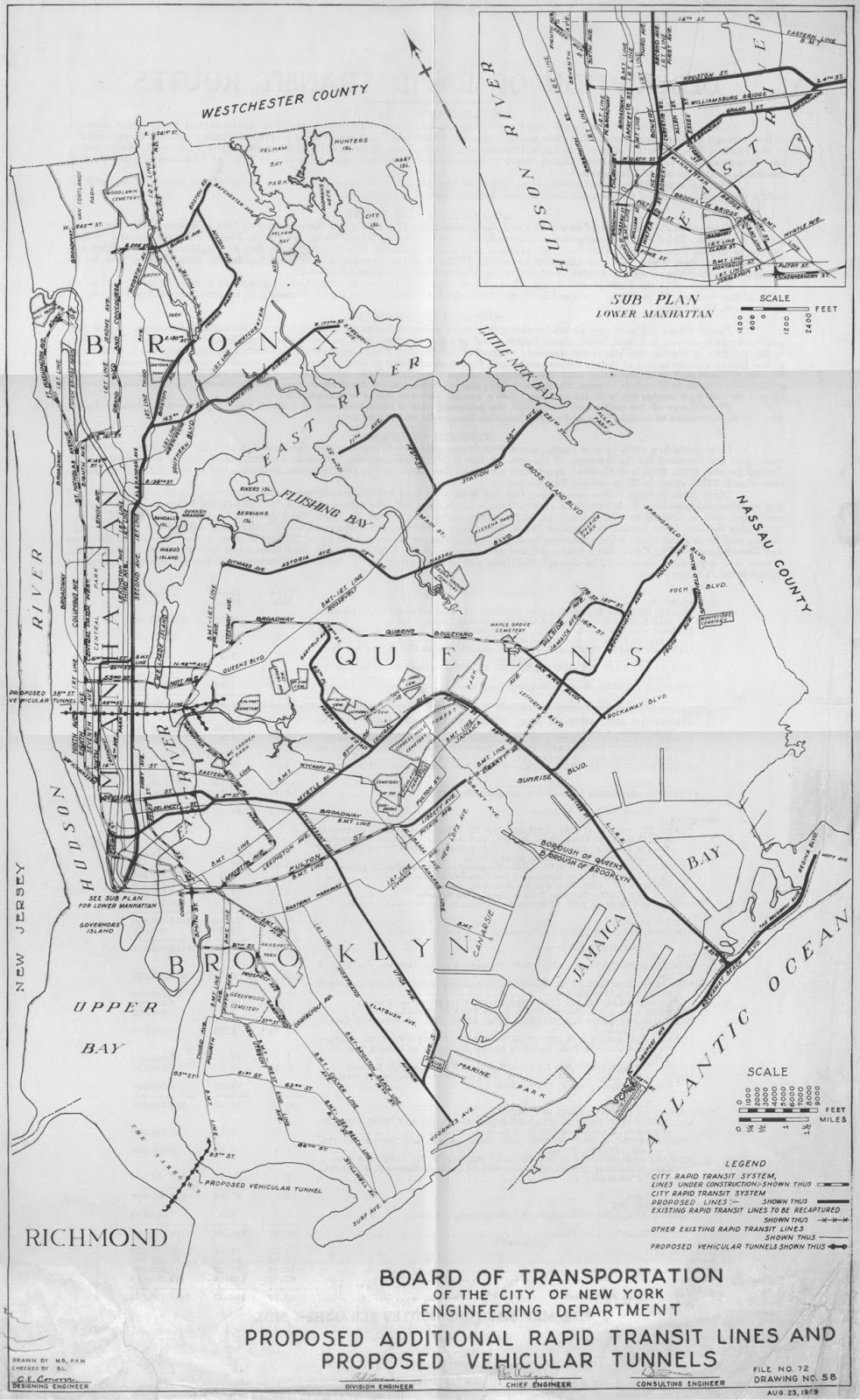
In the years since Westway's September 11, 1985 cancellation, a series of other projects have been proposed for reconstructing certain antiquated design highway segments largely or primarily within all new highway tunnels, such as the Gowanus Expressway in Brooklyn, and just to the north, that highway's essential continuation as the Brooklyn-Queens Expressway, including the option of a tunnel to bypass the rather artfully done triple level segment to the south of the Brooklyn Bridge retaining it as a local collector distributor, with the mainline relocated into a new tunnel.  The proposed Gowanus Expressway Tunnel received a major public promotion by the Regional Plan Association in 1996-1997, being addressed by NYSDOT with a study, with the proposals for the BQE to the north so addressed by the authorities more than a decade latter.  A new set of tunnels would go far towards relocating much of this traffic flow out of sight, smell and sound while accommodating some useful extra capacity- which I heard opposition from one particular planner who was simultaneously advocating altogether decommissioning or even demolishing the triple level segment despite its architectural significance!  For the BQE, one proposal was for a short tunnel to bypass the triple deck promenade, while another was for a longer tunnel essentially continuing the straight line of the Gowanus Expressway altogether bypassing the approach to the Brooklyn-Battery Tunnel.

Another idea more recently heard about, but with no reported official planning study is for a "Big U" landfill with parkland atop an enclosed box tunnel highway around the southern end of Manhattan, promoted as a storm barrier to protect from flooding.  This would relocate a portion of the FDR Drive underground, and would conceivably revive Westway, perhaps with some design variations.

Alas the Obama Administration would deny funding for the BQE project, hence putting it off into the future.

And despite the longer amount of time that we have been hearing about a Gowanus Expressway Tunnel, planning for that appears to have floundered.  No construction project has been started or announced.  And the planning process has dropped all of the route alternatives directly along the existing elevated freeway nor the parallel streets, hence limiting itself to a sole route option directly along the waterfront likely involving some degree of new land-fill, and having me wonder if that is a set up to block it upon the sort of argument used against Westway regarding aquatic life, or perhaps at least drive up its costs, as their appears to be ample space to construct a set of tunnels along the existing highway under 3rd Street.

Nor have we heard any other proposals to at least deck over some existing freeway segments, perhaps the I-87 Major Deegan Expressway in the northern Bronx, nor any planning vision officially or from any funded organizations for reconstructing the segment of the Deegan south of Yankee Stadium within a new modern spec tunnelway, whether or not staged as the Cincinnati I-71 Fort Washington Way depressed freeway designed to be given a roof later.  Indeed, far worse, the authorities have permitted development to encroach upon the lightly developed industrial properties and abandoned railroad right of ways adjacent to these stretches of highway that would be highly useful for such projects, thus locking in antiquated and divisive highway designs for the sake of speeding up short term developer profit.

Nor have we heard anything about reviving the single most important previously proposed highway tunnel proposal that was rashly included in the mass cancellations of planned freeways in 1969 by N.Y.C. Mayor Lindsey who had previously made some excellent suggestions about better reconciling urban highways into the areas with a maximum use of existing corridors and tunnel enclosures- the Cross-Brooklyn Expressway-Linear City that would provide a parallel route to the highly used Long Island Expressway, relieving traffic from that and the connecting segment of the BQE-Gowanus Expressways.

Nor have we heard any serious proposals, only lip service to he much touted concept of decking over portions of the Cross Bronx Expressway, despite the various favorable mention of such by such groups as the Tri State Transportation Campaign.

Rather, the biggest political push within Greater New York City was a recent campaign to remove the Sheridan Expressway in the south Bronx, one which had to retreat owing to the obvious benefit of retaining its underpass beneath Westchester Avenue rather than route such traffic that includes numerous trucks through the traffic light intersection to and from Hunts Point Market.  This campaign is spurred by a desire to improve local access to the Bronx river waterfront.  However it likewise overlooks the topography that would better allow that via a deck atop a portion of the Sheridan.

Within the Greater New York Metropolitan area, the single most significant highway project proposal is the Cross Sound Tunnel connecting I-287 in Westchester County with Route 135 in Nassau County, replacing the Cross Sound Bridge proposal that was actively planned by Robert Moses but canceled in 1973.  That would provide Long Island with a direct access to the mainland that would not pass through New York City.  It would open up a direct access from Long Island towards New England (the current I-287 terminus at its interchange with I-95 is just inside the New York State line with Connecticut, and I-287 connects with the northerly running I-684 which connects with I-84).  And it would divert a significant amount of traffic from I-95 in Westchester and the northeast Bronx, and the connections to and via the Whitestone and Throggs Neck Bridges, plus much of the Long Island Expressway.  It would employ drilled tunnels to avoid the impacts of a bridge, and would construct the 135 extension as a tunnel, with the cut and cover southern end of that beneath new parkland and recreation facilities, rather than simply being an exposed freeway.  This would all address the local environmental concerns while providing what would be a much useful added evacuation route out of Long Island, a particularly logically greater concern since 911.

Nonetheless the Cross Sound Tunnel planning has politically floundered.  Reportedly then N.Y. Governor Elliot Spitzer favored it, and was set to announce his support publicly for a plan that would have funded it via Bears Stear, before being felled by a sex scandal involving his patronage as "Client #9" of a brothel "Emperors' Club", via a barrage of NY Post/NY Daily News tabloid reporting that never bothered addressing Clients #s1-8 nor #10 and higher in what was clearly a brothel catering to politicians and other leaders.  The timing of this questionable publicity and the subsequent collapse of Bears Sterns has been suggested as being meant to thwart the tunnel.  As can be expected, even this tunnel is being opposed by some within the wealthy neighborhoods at each of its ends in and near Rye and Oyster Bay, despite its many differences than the past Robert Moses era proposals.

The Manhattan Institute and its City magazine could be doing far far more to advance ideas as these to get beyond the political malaise of continually neglecting improving the highways- whether operationally or even environmentally via placing more within tunnels to enclose noise and pollution while improving local connectivity.  After all, are not cities all about creating multiple levels of space to accommodate and reconcile greater human activity with in a given footprint.

Alas, to its detriment and that of the greater New York Metropolitan region, "The Manhattan Institute" has gone in the opposite direction by pandering to the same sort of reactionary ideology leaving the authorities to continually, for the sake of catering to a relatively small number of more affluent people in a wealthier area- as evident by their response to Governor Cuomo's support for a Cross Sound Tunnel, via their spokesperson Nicole Gelinas:

https://www.manhattan-institute.org/html/when-it-comes-infrastructure-cuomo-has-tunnel-vision-8354.html

The New Year has begun, but Gov. Andrew Cuomo evidently did not make an important resolution: stop announcing huge infrastructure projects without a way to pay for them. This week alone, Cuomo unveiled three projects worth billions of dollars, even as nobody knows how to fund last year’s projects. There’s nothing wrong with building infrastructure – in fact, it’s a good thing – but Cuomo has to starting picking his projects wisely, and then put some real cash behind them.

Cuomo’s [Long Island Sound] tunnel idea would inevitably take away money from something else, perhaps something more useful.
Cuomo stakes his legacy on big stuff you can touch. On Tuesday, he cited Robert Moses, New York’s mid-century master builder, in saying that “somewhere along the way, we lost our daring.” The governor said that, like Moses, we have to “think big” and stop it with NIMBY-ism.
It’s true that Moses built some great stuff – but also true that he built some pretty bad stuff, including highways like the Cross-Bronx Expressway, which helped hollow out the Bronx six decades ago.
One marquee project Cuomo announced Tuesday represents Moses’ worst impulses. The governor said that he wants to build a car tunnel underneath the Long Island Sound, connecting the island with Connecticut, Westchester or the Bronx.

Such a tunnel would precipitate a lot of, well, NIMBY-ism – but for good reason. In 1964, around the time Moses was finishing the Cross-Bronx, he proposed a bridge over the Long Island Sound, something he said was a “fetish” for him. (Hey, to each his own.)

Nine years later, Gov. Nelson Rockefeller killed the idea. Local residents had for years agitated against a project that, as the New York Times put it, would “overload existing road systems, harm the ecology and the recreational value of (the) Long Island Sound, and destroy the communities in the path of the access roads.”

The residents were right, just as the people who killed the proposed Westway highway project along the Hudson River in Manhattan in the same era were right. We do not solve traffic problems by building more highways; new highways only cause more traffic.

Yes, a tunnel would have less impact on local towns, but it would have some impact. Think of the access ramps and such that the Lincoln Tunnel, Holland Tunnel and Brooklyn-Battery Tunnel need. The worst effect, though, would be more cars on local highways and streets already choked with cars.

Moreover, when Moses proposed infrastructure projects, he found ways to pay for them. Building a tunnel under the Sound would cost billions of dollars. But the governor hasn’t yet proposed how to pay for his existing crossing project: the $3.9 billion Tappan Zee Bridge replacement, under construction north of New York City. This week, the governor did the opposite, proposing to freeze and even reduce tolls on the state’s Thruway system for another five years, at a cost of $1 billion.

Cuomo’s tunnel idea would inevitably take away money from something else, perhaps something more useful. Cuomo’s other major proposal on Tuesday was to build a new, 10-mile track on the Long Island Rail Road. This is actually a good idea. Right now, track constraints mean that the LIRR can run trains only in one direction much of the time, meaning people who would like to take the train have to take a car instead, or wait hours. And here, Cuomo’s policy team seems to have actually thought some issues through: reducing the number of houses the railroad would need to seize, for example, from 200 in an older plan to 50 now, would lower costs and mitigate community opposition.

The problem, of course, is money. A new track would cost well more than $1 billion (anything we do in this state costs at least a billion dollars). Meanwhile, the Metropolitan Transportation Authority, which would build the project, still has no idea how it’s going to pay for its existing expansion projects, including the $10.2 billion East Side Access project, another LIRR expansion.

One way to fund the new track would be to ask Long Island towns and villages to assess a fee on new apartment developments along the route. This would show that Long Island is willing to increase its density, which is the entire point of building anything at all. But here, too, with the Tappan Zee, expect Cuomo to start building (or at least studying) now and paying later.

- anti Cross Sound Tunnel

- and anti Westway.

- and close minded upon new ways of funding, nor of the potential benefits of perpetual extra property tax revenues- an issue perhaps completely ignored by the great public "debate" over Westway.


Is not it interesting how a supposedly "right wing" think tank spouts the same rhetoric of the left wing 'progressives'?

"... pretty bad stuff, including highways like the Cross-Bronx Expressway, which helped hollow out the Bronx six decades ago ...One marquee project Cuomo announced Tuesday represents Moses’ worst impulses ... build a car tunnel underneath the Long Island Sound, connecting the island with Connecticut, Westchester or the Bronx. Such a tunnel would precipitate a lot of, well, NIMBY-ism – but for good reason. In 1964, around the time Moses was finishing the Cross-Bronx, he proposed a bridge over the Long Island Sound, something he said was a “fetish” for him. (Hey, to each his own.) Nine years later, Gov. Nelson Rockefeller killed the idea. Local residents had for years agitated against a project that, as the New York Times put it, would “overload existing road systems, harm the ecology and the recreational value of (the) Long Island Sound, and destroy the communities in the path of the access roads.”

NYMYISM against a Cross Sound Tunnel would be for "good reason" while mentioning the Cross Bronx Expressway?!  Such a juxtaposition is revealing.

The east-west Cross Bronx Expressway, connects the George Washington Bridge with points east largely , as a segment of I-95, with connections to the Whitestone and Throggs Neck Bridges to Queens County in western Long Island, passes through densely developed areas, and is highly congested.

The approach highways to the Cross Sound Tunnel or Bridge, I-287 and Route 135 are less congested and as they pass through far more lightly developed areas, would be physically infinitely easier to widen that the Cross Bronx Expressway

The Cross Bronx Expressway passes through relatively lower middle economic class neighborhoods, while the areas around the I-287 and 135 and their respective I-95 and I-495 crossroads are relatively highly affluent.

As the Cross Bronx Expressway passes in close proximity to numerous apartment buildings, its lack of enclosure within a tunnelway is infinitely more acute.

The lack of a Cross Sound Tunnel nor Bridge has the primary effect of routing more traffic upon the Westchester and northeast Bronx segment of I-95 and the Hutchinson River Parkway, plus the Long Island Expressway through eastern Queens, and Nassau County

Meanwhile, the lack of an I-95 segment in more rural northwestern from Trenton to I-287 places additional traffic upon the Cross Bronx Expressway- a segment that was canceled in 1982 owing to political opposition from the more affluent towns along and near its route, despite the area being far less dense.   Let us not forget this part of the broader picture.

So what Nicole Geliner is writing is that wealthier areas should continue to get over upon less affluent areas by stopping a proposed highway tunnel, never-mind that they are getting to stop a tunnel, and/or represent an area far far less densely developed, while less affluent areas get more traffic upon highways that are not enclosed in tunnels, even in such less affluent areas that are densely developed as the Bronx.

Disgusting.

Don't forget such opposition is not about deferring such projects as the Cross Sound Tunnel or Bridge, with an argument to building the proposed rail transit projects before embarking upon the Cross Sound Crossing.  Rather, it is to never build the Cross Sound Crossing.

Hence the distraction from any discussion of alternative ways of funding.  And hence the appeal to emotion with the blurring the histories of a conventional surface freeway carved through a densely developed poorer area with some questionable planning decisions as Robert Moses' failure to enclose all but a few short segments within tunnels and a routing through the East Tremont neighborhood rather than an alternative route one block south that would have been far less impactive, with another freeway through a far more sparsely yet wealthier area- even with the latter as a full length tunnel!.

The Manhattan Institute can do infinitely better than continually pandering to this environmental classism-racism.

Tuesday, February 9, 2016

London's Mayor Continues To Promote Future Underground Motorways

London's Mayor Boris Johnson follows up his previous proposal for an underground 'orbital' motorway tunnel, that would essentially serve as a replacement for a 1960s-early 1970s plan for a "motorway box", with a pair of two new east-west motorway tunnels.

See my 2015 post on this here:

http://cos-mobile.blogspot.com/2015/02/london-looks-to-underground-motorways.html

The new proposed tunnels, with a combined length of about 26 miles, are shown in this map below in blue:


These two main east-west tunnels would be accomanied by 9 new 'fly-unders' at various points throughout London.  A better map of all of this can be found here:

http://www.theguardian.com/uk-news/2016/feb/04/boris-johnson-london-road-tunnels-congestion-air-quality

The northern tunnel - the Northern Cross City Corridor -would be 18km in length, connecting at Park Royal to the west with the A40 - the main highway for Birmingham, Manchester and Liverpool, and to the east in Hackney Wick with the A12 towards Dover.

The southern tunnel would be 25km in length, tunnel would connect the A4 in Chiswick to the A13 in Beckton.

Mayor Johnson stated that the tunnels could cut congestion in central London by 20%, and be funded by tolls.


The map above has been accompanied by a artists rendering of the redeveloped space atop.


The space atop these tunnels and fly-unders would feature new development.  Such real estate development, plus tolls are being promoted as ideas to pay for the tunnels' construction.


Tuesday, February 2, 2016

PIRG's Continuing Reactionary Opposition to Freeway Network Expansion


Places ideology over needs via opposing seriously needed road projects,
such as widening I-95 in Connecticut, and a Tunnel in Pasadena, California
to establish a continuous I-710   


http://uspirg.org/reports/usp/highway-boondoggles-2

The report lists a series of highway projects which it deems as questionable, based more upon ideology against any highway capacity expansion projects than an understanding of local and regional needs.

Two particularly egregious examples of this is their opposition to widening I-95 in Connecticut with one additional lane in each direction from its existing 3 lanes in each direction configuration that it was originally built with during the 1950s, and to the idea of a tunnel to eliminate the I-710 gap in Pasadena, California as the least locally impactive method, following the past rejection of conventions surface and cut and cover designs.

About Connecticut I-95


Connecticut I-95 is that state's sole grade separated open to mixed traffic highway in the densely populated  20 mile wide band along the coastline along the Long Island Sound, with the nearest such parallel highway I-84 being some 20 miles inland, with the 2 lane per direction Merit Parkway (closed to trucks and commercial traffic) some 4 miles or so inland the sole such other grade separated highway option between, and is paralleled by the Northeastern railroad corridor that carries rail cars from New York to Boston.

I-84 would be the physically easiest to widen, but is the furthest from the densely populated coastal area.

The Merit Parkway is significantly closer to I-95, but is politically difficult to widen owing largely to its iconic bridges which would have to be realistically either reconstructed or twinned, and would still not be suitable for large trucks.

The parallel railroad should be upgraded to permit improved rail service. 

But I-95 should still be widened.

Favoring one mode of transport should not mean neglecting capacity improvements to the other.  Highway and rail can relive each other to varying degrees more than they can altogether substitute for one another.  Rail is more adaptable to absorbing longer distance trips, while highways are more suited to many other trips owing to the time savings of direct door to door service.  Expanding both provides for future growth and increased human activity within a given developed area thus somewhat relieving pressures to expand development into more pastoral rural areas.

I-95 in Connecticut should ideally it should be 12 lanes with a 3/3/3/3 or so separate carriageway configuration, akin to that of much of the New Jersey Turnpike, at least from the New York line to past New Haven, as it would accept and distribute traffic to the sole east-west interstate highway just south of the N.Y. line in Westchester County (and conceivably from a bridge and or tunnel crossing of the Long Island Sound to existing Route 135 in Long Island)- I-287.

As such a "duel barrel" configuration would have relatively high right of way requirements, a more feasible option would be widening it from a 3/3 to a 4/4 or 5/5 configuration, designed with a long term staging plan for parallel carriageways, with segments built in spots where more needed and more physically practical in an outboard configuration, designed to be later made continuous with added segments that would tuck underground beneath the existing carriageways to reduce local impacts.  Such a staging would be financially more practical, with the design including the road substructure to permit the later excavation of the underground segments without having to tear out the road.

To further reduce impacts, portions of this widened I-95 should be designed to accommodate various decked segments, with local overpasses made wider to include better pedestrian and bicycling connections, and with some provisions for future air rights development.  Perhaps certain elevated I-95 segments, as that in New Haven could be reviewed for reconstruction in a fashion via enclosures through new buildings, with access ramps reconstructed via a center rather than a side loader configuration for better accommodating vehicular and local pedestrian traffic.
 
To help relieve Connecticut I-95, particularly from I-287 in New York to past New Haven, the eastern portion of Westchester I-287 should be widened to at least a 5/5 configuration to I-684, which itself should be widened from 3 to 5 lanes in each direction.

About CT I-95
http://www.nycroads.com/roads/ct-turnpike/

About Pasadena I-710


This is a longstanding gap in the highway network in need of filling.

It initially resulted form the physical reality that the area of Pasadena, California is largely older more historically significant architecture built well before the mass freeway era, and from poor planning decisions to permit mass real estate development construction in a band to the west, particularly without any consideration there for the idea of doing such atop a cut and cover-box tunneled freeway.

Past plans for a conventional surface cut freeway through the long established Pasadena residential neighborhoods would die political deaths owing to popular revulsion over the demolition and/or moving requirements.  Likewise with later plans for a tunnel via the cut and cover method for that would have likewise involved surface displacement though without such permanently, particularly if the existing buildings were replaced or re-situated atop.

Subsequently, the official planning has turned to completing the I-710 missing link via a tunnel that would be moled (IOW drilled or bored) hence not disrupting the surface for almost all of its length, with the exceptions being for its relatively brief cut and cover transition segments at each of its ends, and for any ventilation components.

Current planning is for either one or two tunnel tubes, each with 2 levels, each with 2 lanes and a shoulder, providing a total of 4 or 8 lanes in total.


The 710 Tunnel project is a vitally important project for Pasadena and for the Greater Los Angeles area, for providing local relief for 710 traffic that must now detour to local streets or to parallel regional freeways as I-5, 170/101, and I-405.  It would be about 4.9 miles long, connecting freeway stubs each with 3 or 4 lanes per direction.  It is estimated to have construction costs of $3.2 to $5.6 billion, and would receive funding from tolls of about $15 for trucks and $5 for most other automobiles while providing savings in time as a relatively continuous high speed route.

LA's north-south freeways are particularly badly congested largely owing to the east-west mountains to the north separating LA from the San Fernando Valley, blocking the construction of capacious parallel routes via the local street grid.

A continuous 710 is particularly important for the port of Long Beach, with 710 already a major truck route.

LA's transportation problems also stem from a lack of a comprehensive passenger rail network, caused by the foolish decision to rip out its rail car transit system during the mid 1900s.  And 710 completion opponents may well be right in their prescription for various additions to the region's sorely in need of expanding rail transit system.  But they are wrong in outright opposing the 710 completion project for a drilled tunnel link, and would be better in asking for a broad transportation planning vision for rail and highways, perhaps one via splitting the 710 project into stages with the initial construction of a single double decked tunnel tube with the extra funds diverted to the transit projects before the future construction of an addition tube or tubes.

Perhaps there might be better economy to replace the double-decked 2x2 tube design with a larger diameter accommodating a 2x3 lane configuration?  Or perhaps one featuring the former to accommodate trucks, accompanied with a lower height version of the latter for accommodating most other vehicles?  Such would provide a total of 10 lanes with 4 for trucks and 6 for smaller vehicles, and should be evaluated together with options for staging either 2x2 or 2x3 double level tunnels so staged to ultimately provide 2 or more separate tubes.

With the LA region so starved for north-south cross mountain road capacity, throwing away any capacity for future additions, whether via highway or via railway should be viewed as criminal.

PIRG would do so much better by eschewing its reactionary ideological opposition to future highway capacity expansion to a more balance view that would instead debate how projects should be staged, permitting some highway expansion together with rail transit additions, rather than simply the latter.

Likewise, various DOTS need to include the idea of future staging into their basic designs allowing future capacity additions with minimal demolition of existing construction.   For instance, the recent I-405 widening project should have been designed to accommodate future capacity additions, if not for continuous outboard or elevated carriageways, should have taken advantage of any space for access into parallel tunnelways, either directly beneath the existing mainline with the necessary substructure to permit excavation beneath without having to rip out the road/and or for such as a moled tunnel.  Consideration of such staging should likewise not reflect the narrow transit only ideology prevalent in PIRG, via not excluding designs to help facilitate adding a future transit line.

Pro I-710 Tunnel Site
http://www.710coalition.com/

Anti I-710 Tunnel Site
http://www.no710.com/

Wikipedia I-710 article
https://en.wikipedia.org/wiki/Interstate_710