Saturday, April 9, 2016

Sheridan Expressway 'Boulevardization' Persists


Rejected in 2012, the idea of eliminating the Sheridan Expressway grade separation continues, with NY officials earmarking $97 million for removal, with a new report recommending that its northern, at grade segment be converted to a traffic light signalized boulevard, upon a reduced right of way.

http://www1.nyc.gov/site/planning/plans/sheridan-hunts-point/sheridan-hunts-point.page

Option #3 with right of way reduced to 115 feet
Orange marked cross streets, from bottom: Jennings, 172nd and 173rd Streets

This report displays a number of options for this segment, including narrowing the existing 210 foot building line to building line right of way to as little as 115 feet to facilitate greater amount of real estate square footage to the east.


Option #1 Retain existing 210 foot right of way with flanking service roads
Option #2 Modify-Separated 155 foot right of way, eliminated the eastern service road
Option #3 Modify-Combined 115 foot right of way, eliminates both service road


All of these options would transform the existing surface Sheridan Expressway into a traffic light signalized Boulevard.

Option #3 would essentially require demolishing the recently reconstructed Sheridan roadbed, in order to squeeze it to the west, displacing a separate West Farms Drive.

note that this is in the side of a hill.


Existing Sheridan profile looking north

Advocates for removing the Sheridan Expressway cite improved waterfront access and development, and reduced vehicular pollution as reasons.

But is adding traffic light intersections to what is now a grade separated express highway corridor, that is still fed by freeway segments at both ends between the highly used Cross Bronx Expressway and the Hunts Point Truck Depot really the best solution?


Previous calls for entirely removing the Sheridan Expressway were rejected with the finds that eliminating its grade separated "below grade" under-passing of Westchester Avenue would drastically increase traffic congestion and pollution at the alternative parallel route of the traffic light intersection of Westchester Avenue with Whitlock Avenue.  Meanwhile removing the Sheridan Expressway's "above grade" elevated portion to the south would transfer the traffic further along Whitlock, while doing nothing to address the parallel elevated 'subway' and surface railroad that now flank it and also separate the area from the waterfront.


1st stage of Northern Sheridan Area Re-development


Hence, the planning discussions now focus upon the Sheridan's northern segment.

Except for its transition to its underpass crossing of Westchester Avenue, this segment runs "at grade" along the surface.

And this focus is exclusively upon the idea of converting this Sheridan segment into a boulevard, equipped with three new traffic light intersections, one apiece for the crossings of Jennings Street, 172, and 173rd Streets, and flanked by rows of new buildings.

To the north, the existing grade separation beneath the 174th Street Bridge would be retained, along with the ramp connects to and from the Cross Bronx Expressway.

And to the south would remain the existing Sheridan Expressway, with its underpass crossing below Westchester Avenue, and further south with its elevated viaduct wedged between the railroad to the east, and the elevated 'subway' line to the west, feeding directly into the elevated segment of the Bruckner Expressway, which would have a new set of ramps to Hunts Point Market to better facilitate truck traffic.

And flanking this "Boulevardized" Sheridan segment, new rows of buildings to the west, where the topography rises as a hill, and to the east where it runs flat towards the Bronx River, would replace existing industrial uses and contain hundreds of new residential dwellings.

All of this is being touted as the best option to improving the urban landscape with new park-lands, neighborhoods and jobs, with significantly improved local access to the Bronx River waterfront.

Really?

New development facing the lower portion of the Bronx River with enlarged parkland and improved local pedestrian access are all laudable goals, even though displacing industrial uses which could nonetheless be relocated to perhaps Hunts Point.

But how honest is it to combine this with the idea of replacing this surface segment of the Sheridan Expressway with a "boulevard" with three new traffic light intersections, and to issue renderings showing that with 1,000 plus new residential dwellings and presumably far more pedestrians, with no increase in surface traffic upon the replacement Boulevard that would have to handle these new residents plus the vehicular traffic from the Expressway segments at both ends.


Looking North Along Farms Road Before and After The Removal of the northern portion of The Sheridan Expressway - an earlier proposal
Though the latter rendering has this portion of the Sheridan Expressway removed, though still fed by Expressway segments at both ends, and its space taken over by a new line of buildings, with over 1,000 new residential dwellings, it shows virtually no vehicular traffic.

And what about the pretense that its an either-or situation?  That re-development and improved local waterfront access is necessarily incompatible with retaining the Sheridan Expressway as assumed by this seriously misguided campaign to simply remove the Sheridan.

Have Sheridan Expressway removal advocates chosen to shut their eyes?  To fail to try imagining the best of both worlds, eliminating the Sheridan's undesirable local lateral separation, while retaining its desirable longitudinal grade separation of keeping the bulk of the vehicular traffic out of the surface street grid.  Instead just following an often overly simplistic and dogmatic trendy campaign of freeway removal?


Apparently so.

A Sheridan Expressway Tunnel would accomplish this best of both words, with express traffic underground, thus freeing up the surface more for local use.

Placing freeways underground is the best of both word's solution, but is often dismissed as too expensive or difficult.

But this actually a pretty egregious example of keeping one's eyes shut, of a freeway removal campaign  being deliberately obtuse.

Just look at the topography.

The Bruckner sits in a river valley, between the Bronx River to the east, and a hill to the west.

Note how Jennings, 172 and 173rd Streets descend to the existing West Farms Road.

Activists want to facilitate a locally improved environment with improved accessibility to the Bronx River waterfront, and new real estate developments on both sides of this Sheridan segment.

But they are retaining a major vehicular traffic corridor, and thus maintaining the surface separation of the Sheridan Expressway corridor, namely its daily flow of traffic particularly between the Cross Bronx Expressway and Hunts Point market.  Don't forget that this Sheridan segment would continue to be fed by Expressway segments at both ends, and that the area is only going to have far more activity with all of this new development, plus the new ramps to Hunts Point, to say nothing of such further south if the Re-Think NYC plan to add a new terminal to La Guardia Airport and its attendant new development at Port Morris comes to fruition.  Under such circumstances, ONLY a tunnel would achieve a 'Sheridan' surface street that would be truly more like a local surface street than a de-facto freeway.

So why the zero consideration of a 'tunnelization" of this Sheridan segment- especially given the topographical ease and feasibility of achieving this with such numerous cost advantages?

- Such as of NO new excavation.
- Such as of retaining the existing Sheridan Expressway roadbed that was recently replaced with a relatively high quality concrete construction- option #3 would require ripping this out and replacing it altogether.
- And the opportunity of facilitating this with the designs of the yet to be built flanking future real estate development.

Again, note how the streets from the west, Jennings, 172 and 173rd,  drop down to meet West Farms Road, where the planning envisions replacing the existing buildings with new taller/denser buildings, as well as along the eastern side nearer to the Bronx River.  And note that these new buildings flanking the Sheridan segment would be substantial, with significant foundation walls thus framing this Sheridan segment.

To make this Sheridan segment into a tunnel, while crafting a true boulevard on the surface, atop the existing road-bed, construct a new box tunnel enclosure-deck supporting a new surface boulevard atop, directly faced by the "1st" floors of the flanking new buildings, which could have their facing foundations serving as the outer walls of this new tunnel, retaining the existing flanking service roads as underground delivery access for these new buildings, with the streets from the hill to the west leveling out to meet this new boulevard, and a terrace to the east of this new development  facilitating the transition descent to the Bronx River water-front.

Constructing this deck would be an added cost, surely.

But employing the existing road-bed - remember that the option #3 promoted for increased space for real estate development requires ripping out and replacing the existing Sheridan Expressway road-bed - would be a cost savings.

And so would the idea of designing these buildings to serve essentially as the outer walls of this new 'tunnel' that would include the existing service roads potentially used for underground delivery access.  Doing this would furthermore allow the idea of reducing the initial construction costs by deferring the extra walls to coordinate off the now underground service roads from the now underground freeway.  As these buildings have not yet been constructed, designing them for this purpose, including having their '1st" floors to face this new surface boulevard would be infinitely more practical than a retrofit.

This new deck would start at some point to the north of 173rd Street, and extend south to the vicinity of Jennings Street, if not further to as far as Westchester Avenue, depending upon several planning decisions.  For instance it could extend as far north as the bridge which carries 174th Street, with its north-south 'Sheridan' Boulevard descending to connect to the existing West Farms underpass beneath this bridge, or perhaps continue upon its raised grade to a new at grade intersection with 174th Street, before descending to the north in order to connect to the existing underpass crossing of the Cross Bronx Expressway.  Or perhaps it could combine these options, extending to the 174 Street Bridge but with a descent to the existing West Farms Road grade, or even conceivably, extend a bit further north to cover over a portion of the eastbound Cross Bronx Expressway to the southbound Sheridan Expressway ramp.  Similarly, the extension to the south would involve some options, such as those regarding the southbound off-ramp.


By so retaining the existing Sheridan recycled as an underground highway in the least expensive manner possible with NO new excavation and freeway roadway replacement, with the existing highway enclosed in a new tunnel box constructed atop further facilitated by developer cooperation with the new buildings alongside --  in sharp contrast with Boston's Big Dig which actually relocated Boston's I-93 Central Artery in all new lowered tunnels --such an underground configuration would make the new development more pleasant and valuable, making such a lid more economically viable. 

That such an idea does not even appear in any of the great urban planning discussions,speaks volumes of the controlled, dogmatic and not very imaginative nature and political dynamics of such organizations as the Congress for New Urbanism.


http://www1.nyc.gov/assets/planning/download/pdf/plans-studies/sheridan-hunts-point/final_1_3_analysis.pdf


Wednesday, April 6, 2016

3/31/16 Collapse Spotlights India's Hideous Roadway Urban 'Flyovers'


While areas worldwide are constructing unobtrusive underground motorways, India goes in the opposite direction with flyovers- elevated roadways of varying merit, including those placed above city streets, mere feet from people's bedrooms, as this in Calcutta with the Vivekananda Road 'flyover'


"Work on the Vivekananda Road flyover, which started in 2009, has gained pace after a long lull. The flyover, that will connect Girish Park and Nimtala Ghat Street to Howrah bridge, would allow commuters to bypass the congested Posta crossing.

Construction had almost stopped last year because of technical problems as well as objections from residents who apprehended accidents because the flyover runs close to their homes, said the authorities of Calcutta Metropolitan Authority (CMDA)."

The 1.4 mile (2.2 kilometer) long Vivekananda Road Flyover is one of a series of such elevated vehicular road 'fly-overs' constructed in India in recent years, itself being started in 2009.


The Vivekananda Road flyover is perhaps India's most extreme example of cramming an express roadway through a densely built up urban area, and numerous other Indian flyovers seen in various articles available via the internet, such as this, appear to be far less inappropriately situated, for instance not placing motor traffic directly by people's residences.

As can be seen from a google ariel, it has two main segments that are largely completed, with a not yet finished connecting segment, that collapsed on March 31, 2016, bringing the project much new attention.


The collapse occurred at the segment where the street has a right of way kink at the intersection with  Rabindra Sarani, where the designers were thus forced to use a single vertical support with cantilevers on each side, rather than double vertical supports as done on the rest of the viaduct.

 
  Kinked Right of Way


Single Vertical Support with Cantilevered Arms


 Customary Twin Vertical Supports


http://indianexpress.com/article/india/india-news-india/the-sunday-story-flying-under/

I think it seems quite clear what the fault is that caused the overpass to collapse in Kolkata. I can see that it may have been bad welding and even more profoundly bad engineering design (or bad construction if the drawings were not followed). The right arm of the support that collapsed was constructed with only a center column and two cantilevered arms. All the others had two legs and were thus not so structurally risky. It appears that the right arm broke off first, and then the left arm – absent its counterbalancing weight – simply buckled. The fault seems to be with the engineers, and not just with the builders, as it seems to me to be a particularly weak detail that would be prone to buckling because the members that held up the whole deck appear to be made up with tubes with sheets of steel no deeper in section than the steel beams that supported the deck along its length, with their ends resting on this weak cantilevered post and beam. The bending force at the top of the column must have been terrific, but it would appear from the buckling that the bottom cord did not even cross over the top of the column, as the column penetrates through the pair of cantilevered beams to terminate at the top cord. Wow! The reports said that they had just poured the concrete deck in this section when it failed, so it was simply inadequately designed to carry the weight of the road, never mind the traffic that will eventually be on it. The anomaly in the pier design seems to be because the road went around a bend in the street with a roundabout underneath – thus they did not want two legs on the support structure, but that has proved to be a mistake of gigantic proportions. The claims that this was an “Act of God” in my mind are incredibly misleading. Signed Randolph Langenbach ()

The above statement presumes that God acts only singularly and not sequentially, but is otherwise valid.

Though the collapse occurred at this naturally more vulnerable area, the project in general, and some other flyovers, have been criticized for poor quality construction.  The culmination of factors would thus work sequentially to bring about this March 31, 2016 collapse.

Matters of construction quality asides, how appropriate are elevated above street vehicular roadways in dense residential urban areas?   Even if well designed with relatively attractive undersides with added lighting, they introduce vehicular traffic mere feet from people's dwellings, with the attendant noise and safety risk from errant vehicles, and even with well designed enclosures, are visually significant, and thus should be accompanied with monetary payouts to the affected neighborhood.

Infinitely more appropriate for such contexts would be constructing additional vehicular roadway levels as tunnels, either drilled and or cut and cover.  As a relatively wide east-west traffic corridor, Vivekananda Road arguably could use a 2 lane plus one shoulder per direction cut and cover tunnel, somewhat akin to that beneath Washington, D.C.'s DuPont Circle.  If additional capacity is needed, the tunnel could have a lower level doubling the capacity, simplified with that being for longer distance traffic to thus reduce the costs and space requirements of having full access ramps for both levels at all of the planned intermediate access points.  The initial construction costs would be likelier higher than a viaduct, thusly why the consultants involved went with a viaduct.  But would not a viaduct in such a context be costlier in reduced property values?  And perhaps a cut and cover tunnel could be accomplished more cheaply if employing prefabricated segments, and made more practical by construction staged first with the upper level as pre-stressed tunnel box segments within slurry outer supports that extend deeper to thus allow the subsequent excavation of the lower level.

Additionally, for the broader picture, cities as Calcutta could improve highway networks via a greater use of the often wider right of ways exclusively used for railroads- in ways to not merely respect of improve the railroads, but to go further and heal the urban scar of vast rail-yards that divide local areas.

For instance, to the north of this viaduct, Calcutta has a generous somewhat paralleling railway corridor, that could conceivably re reconstructed to accommodate more than the existing rail activities- adding transportation options within a new set of tunnel boxes- of a new vehicular highway, improved rail service, while providing additional amenities atop a deck over with new buildings and linear parkland for the benefit of society at large. 

The new tunnel box vehicular highway could be achieved by one of several ways: a cut and cover tunnel directly beneath the railroad; one along the railroad; or perhaps as an ariel tunnel hidden within such new buildings, as done with an autobahn segment in Wilmersdorf, Berlin, Germany, or in the U.S.A. with Seattle,Washington's un-adopted Route 99 'Choppway' proposal; and such could also be adopted with a reconstructed or new rail transit line. 


Quality of construction and design should matter to those who state to be concerned about the impacts of transporation infrastructure.

Notably, publications as Streetsblog have not had much reporting upon such projects, as if the going on in third world countries matter little to the big money behind such publications that primarily focus upon shifting traffic burden to less affluent areas.

Saturday, February 27, 2016

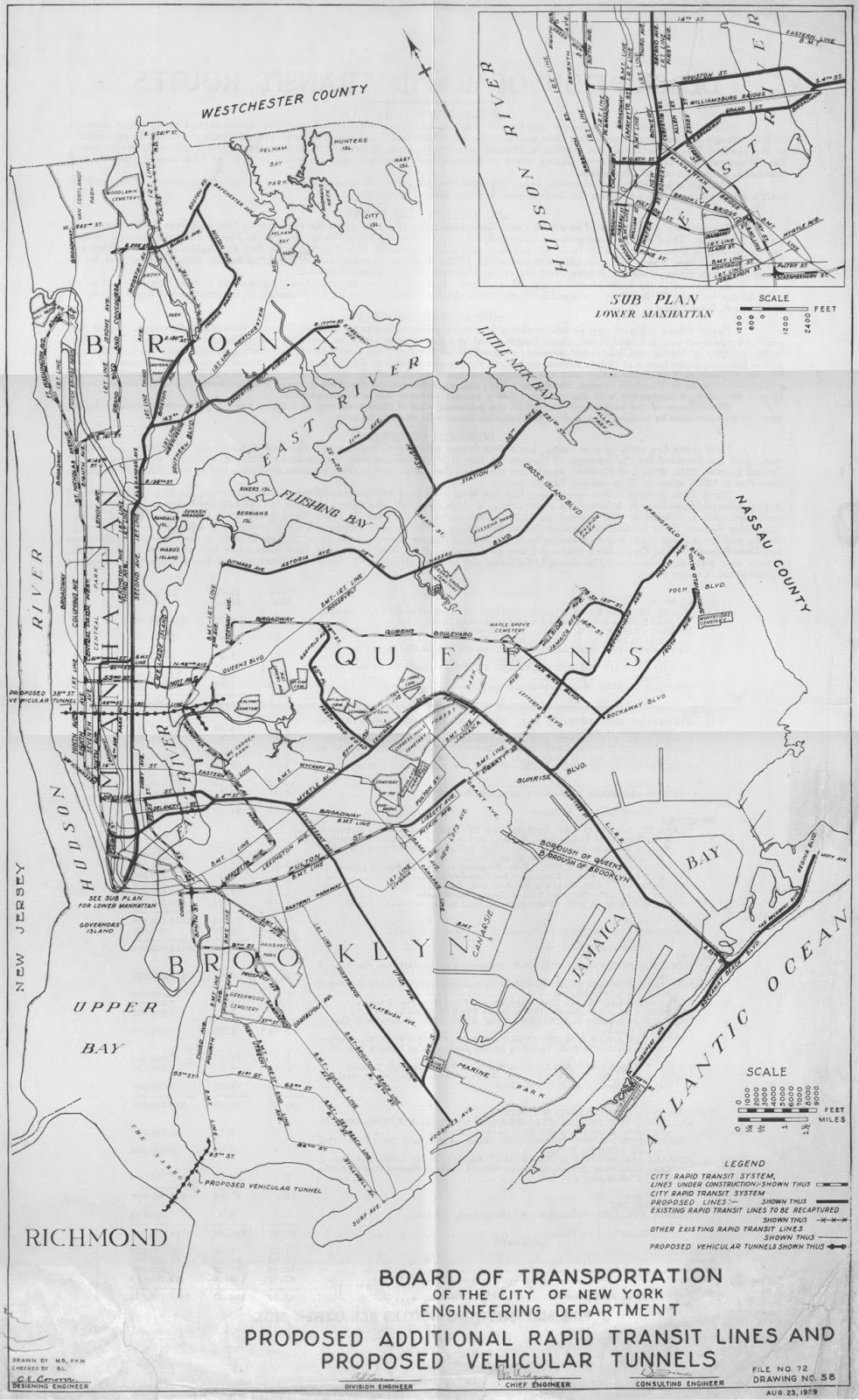
1929+ Mid Town Manhattan Expressway Tunnel

from a map found at this article at Wired:

http://www.wired.com/2013/08/hyperreal-cartography-city-maps/


1929 Proposal 
For A 38th Street Mid Town Manhattan Vehicular Tunnel


No further details yet upon what would have been 2 lanes wide, due to the narrow width of 38th Street, such as if this was for a single level tunnel with one lane per direction, or rather a double level tunnel with 2 lanes per direction.

Note the additional proposed vehicular tunnel at the approximate location of the Verrazano Narrows linking Staten Island and Brooklyn.

About a Regional Plan Association proposal in 1937:

http://www.nycroads.com/roads/mid-manhattan/

WHY NOT A MID-MANHATTAN TUNNEL? As early as 1937, the Regional Plan Association advocated construction of a four-lane, twin-tube tunnel under 36th Street and 37th Street. According to the Moses-headed Joint Study, the chief argument against the Mid-Manhattan Expressway Tunnel was its cost. This would have ranged from $119 million for a no-exit, express link between the Lincoln Tunnel and Queens-Midtown Tunnel, to $145 million for a tunnel link that would have provided entrances and exits at 5th Avenue.

The proposed construction method was described in the Joint Study as follows:

It would be necessary to build two separate tubes under adjacent crosstown streets. A two-lane eastbound tube could pass under 29th Street; a two-lane tube westbound under 30th Street. Ventilation buildings would be located in the block between 29th and 30th Streets fronting on the west side of 8th Avenue and the east side of Lexington Avenue. The least costly type of construction for such a tunnel would be the steel-bent and concrete subway-type, installed by cut-and-cover method.

The tunnel providing only two lanes in each direction would, of course, have only two-thirds the capacity of a six-lane expressway. Provision of more than two lanes in each tube is not feasible due to limitations imposed by building foundations on either side of 29th and 30th Streets and extremely high costs. Limited street access in Midtown could be provided in the vicinity of 5th Avenue at a cost that would depend on the degree to which the interchange was developed.

To accommodate future traffic along the Mid-Manhattan corridor, Moses proposed construction of a $120 million third tube to the Queens-Midtown Tunnel. The third tube, which would allow four lanes of traffic in one direction during rush-hour periods, was to be constructed in conjunction with the expressway.


Monday, February 15, 2016

Re-Think New York City La Guardia Airport Expansion Into The South Bronx Proposal

An intriguing idea to expand La Guardia Airport with expanded runways achieved by new landfill displacing Rikers Island, with a new set of entryways in the Port Morris area of the South Bronx, accompanied by upgrades to the passenger rail system- all well and good.


Would establish new supplemental entryway to La Guardia in the South Bronx, thus traffic from the north would no longer need to cross the Triborough or Whitestone Bridges, with access to the rest of the airport via a dedicated rail loop

 
 Would expand runway capacity via new landfill displacing Rikers Island


 Would connect with all three northern radial Metro North Railroads, thus travellers from the north could arrive by any of the three Metro North railroad lines.   
The train station would include a new stop for Amtrak.

Includes the idea of a new convention center replacing Javits Center.

That's an idea that builds upon late 1800s and early 1900s planning proposals to develop this Port Morris area, such as an 1883 proposal for a new convention center, and latter with the idea of continuing the denser development seen in Manhattan further forth, for which the New York, Westchester & Boston railroad, which opened in 1911 had anticipated.


The Re-Think NYC site notes:

The area north of the convention center would be built at an urban scale.  To the west is the Bruckner Expressway, which prevents connection between Port Morris and neighborhoods to the west.  We would bridge this divide through a proposed new "ambassador" building on the west side of the Bruckner at 142nd Street, which would allow people to enter on that side of the expressway, but the building would also serve as a bridge over the Bruckner that would connect to the entire complex.

This proposal needs further work regarding the highway network, particularly as the Bruckner segment along this area is an unsightly elevated freeway- hence placing a building atop it in this configuration would be ungainly.


Should ultimately include a complete replacement-reconstruction of the southern Bruckner Expressway- an unsightly elevated highway.


What To Do About The Bruckner Expressway:

This elevated freeway, with 3 lanes in each direction is unsightly, locally divisive, lacks shoulders, lacks access ramps to this proposed airport entryway complex, and is under-capacity for accepting traffic from the northbound Willis Avenue Bridge from Manhattan.

It does provide a fantastic view through the windshield for travellers heading south.

To the west it is paralleled by a 4 lane wide southbound surface Bruckner Boulevard.

To its east it is paralleled by a 2 lane wide northbound Bruckner Boulevard with buildings, from its southern end to 142nd Street, where the railroad then meets it to run immediately alongside.  That railroad is at a lower grade.

Ideally there should be a new line of buildings designed to reconnect Port Morris with the neighborhoods to the west in the place now occupied by the elevated freeway structure, which should be torn down, with new parallel freeway roadways, with either both directions within new cut and cover tunnel(s), or with the northbound direction in a new cut and cover tunnel, and the southbound direction elevated as the roof of a new line of buildings.

Because the existing elevated freeway must remain in operation throughout the construction project, the first stage would be constructing a new cut and cover freeway tunnel beneath the surface road to the west.

As the Re-Think NYC proposal envisions demolishing the buildings already along the Bruckner's eastern (northbound) side, it could likewise construct a cut and cover tunnelway there as well.  To the north of 142nd Street, this could be done via the existing railroad right of way with the tracks relocated eastward, and with this rail corridor planned to be decked over.  The historic New York, Westchester & Boston RailRoad Station at the north side of Hunts Point Avenue should not be demolished but rather propped up with new supports and retained either in its exact same location or slightly re-indexed eastwards.


Each of these cut and cover tunnels should ideally be at least the of 4 full width lanes plus shoulders.  This might involve some building removal on a brief section of the north side in addition to that one the south side already envisioned by the Re-Think NYC proposal.  This should likewise be designed to tie into the existing 4 lane short tunnel for Bruckner Boulevard traffic beneath the Bruckner Expressway-Deegan Expressway interchange with the approach to the Triborough "RFK" Bridge.  That tunnel should be lengthened both to the south-west to Brown Place, with local street access and a gentler curve displacing the gasoline station there.  And it should be extended to the north-east, with at least one full lane joining into and continuing via an additional lane of the reconstructed Bruckner Expressway.

Once the new cut and cover tunnels are in place, the elevated Bruckner should be demolished, and replaced with a line of new buildings.  Optional would be the idea of an elevated roadway upon its roof; as the purpose of that would be to continue the tradition of the southbound vista through the windshield, this might done only for the southbound direction.  A variation of this would be to have an arial tunnel within one of this structure's upper levels, ala the "Choppway" proposal a few years ago for the replacement of Seattle Washington's elevated double decked Route 99 Freeway.


However, because of the need to retain the existing elevated freeway throughout the reconstruction, this project would have to include at least one cut and cover tunnel on one or both sides of the existing structure- a basic design configuration furthermore favored by the practicalities of establishing on ramp and off ramp access.   Also, the construction could be staged to add an additional cut and cover carriageway between the two new outboard tunnelways once the existing elevated Bruckner is removed.

To the north, the new cut and covers could do wonders for removing the blight of the existing roadways at the mouth of the Bronx River, for both the continuation of the Bruckner and for its connections to the Sheridan.  

Such a cut and cover tunnel Bruckner Expressway reconstruction should extend to Boynton Avenue, thus eliminating the elevated berm segment to the west, meeting the existing Bruckner corridor where the freeway is at ground level, and has the option of transitioning to the service roads to access the Bronx River Parkway.

Such a cut and cover connection for the Sheridan should extend to Westchester Avenue, which is build-able via re-indexing the adjacent railroad to the east.  Further north, portions of the Sheridan should be decked over taking advantage of the topography of the hill to its west to better connect that area with the Bronx River waterfront, such as between E 172 and 173rd Streets.

The new Bruckner Expressway would of course have greater capacity than the existing 3 lane in each direction facility.  The new set of outboard cut and cover tunnels with 4 lanes apiece flanking an inner set with 2 lanes per direction built after the demolition of the elevated structure would provide an upwards of12 lanes, thereby accommodating continuous on lanes for traffic from the northbound Willis Bridge and to and from the new airport access ramps.  Of this, 8 lane would continue to surface at Boynton Street, with a lane apiece to and from the service roads, the remaining 6 lanes with the 6 lane surface Bruckner Expressway, and 4 lanes to the north for the Sheridan.  Providing this extra capacity would allow more traffic to be underground, thus allowing for a more pedestrian friendly Bruckner Boulevard.

With this thought, the project should include such ramp connects into the Hunts Point Market.

Other Ideas:

With the additional of such a significant amount of landfill displacing Rikers Island, another idea comes to mind- what about taking advantage of that to create new roadway crossings between the Bronx and Queens?  

With the Triborough "RFK" Bridge heavily used, even though the "Re-Think NYC" plan would divert some of its traffic by no longer requiring its use from the north to access La Guardia Airport, it would be prudent for long term planning to ultimately seize the opportunity provided by the landfill for the new runway space.

Regarding highways, two ideas come to mind:

- extending the Bronx River Parkway

- extending the Deegan

The logical place would be the area of the Grand Central Parkway-Brooklyn Queens Expressway interchanges.  

Not simply as the junction of these two highways, both of which are heavily used.  

But because that's the location of a rail corridor that has already been studied and proposed as the location of a new interstate highway running roughly north-south between the two roughly parallel highways of the BQE and the Van Wick Expressway.  As planned during the 1960s it was to be known as the Interboro Expressway, and would connect directly with  the contemporaneously planned Cross Brooklyn Expressway.

For a good historic overview of the previous planing for the Interboro Expressway, see the account by NYC Roads Steve Anderson:

http://www.nycroads.com/roads/queens-interboro/

Accordingly it was canceled by 1973.  As planned during the late 1960s-early 1970s it would have included reconstructing a portion of the existing elevated IRT as a subway with the below ground level freeway.  As I have not seen any detailed plans, I don't know if any of the latter planning included any segments as coverways (cut and cover tunnels), rather than simply as an open depressed freeway.

A revival of the Interboro Expressway has been proposed by Peter Samuel's via his publication TollRoads.

As it is a relatively narrow railroad corridor that is generally below grand level, passing through residential area, it would have to be constructed primarily within a tunnel box, and covered with new linear parkland.


Connecting with a Cross Brooklyn Expressway likewise built primarily by tunnelways, this Interboro Route would provide a valuable link into Brooklyn and towards Staten Island and Long Island.


A could be connected to the Bronx by a curved tunnel contained beneath the Re-Think NYC La Guardia Port Morris facility, directly into the Deegan.  Optionally that could include ramp connects to and from the new Bruckner and the Hunts Point Market.

A tunneled extension of the Bronx River Parkway could connect with the BQE-Interboro-Grand Central Parkway, though its logical connection with the latter as a parkway would be best done in conjunction with a demolition-reconstruction of the western portion of the existing La Guardia complex, owing to the geometry.

Such a connection would thus establish a seem-less link between the southern end of New York's longest Parkway -- the Bronx River - Sprain Brook - Taconic which are all really one freeway from the South Bronx towards Albany -- and the Grand Central - Cross Island - Northern State Parkways.

None of these projects would have to be all built at once or together.

Rather they could be built in stages, starting with the incorporation of their initial segments within the "Re-Think NYC" La Guardia expansion project, and within the reconstruction of the adjoining Bruckner.

Including the tunnel box within the new clearing and landfill would be comparably easy compared to failing to plan them and adding later.  As these would be additions between the existing 8 lane Triborough/"RFK" and 6 lane Whitestone Bridges, they could suffice with a minimum of 2 lanes in each direction apiece.

The Deegan-Interboro Connection would provide a valuable bypass of the Triborough "RFK" Bridge and its antiquated Queens approach.  Of course the Deegan should be rebuilt to full 8 lane specifications, as I have previously written about, and its east west segment from Willis Avenue to at least towards Brown Street, should be decked over.  Serious consideration should be given to reconstructing this freeway further to the east at a lower elevation to be likewise decked over as far as practical for connecting with the Triborough"RFK" Bridge, with new parkland atop, more consistent with the spirit of the 1883 Port Morris planning.

Because of their use of the footprint of the La Guardia expansion project, most of this new tunnel crossing construction would not disturb existing neighborhoods nor traffic.